

- Usage in publication:
-
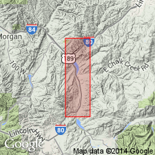
- Wanship formation
- Modifications:
-
- Revised
- Areal extent
- AAPG geologic province:
-
- Central Western Overthrust
Summary:
Pg. 122-123. Wanship formation. In Coalville area, [Summit County], Utah, formation is about 4,950 feet thick. Unconformably overlies Frontier formation; underlies Echo Canyon conglomerate (new). Unit has been considered part of Frontier formation which is herein restricted to exclude unit termed Wanship. Age is Late Cretaceous (Niobrara).
Source: US geologic names lexicon (USGS Bull. 1200, p. 4122); supplemental information from GNU records (USGS DDS-6; Denver GNULEX).
For more information, please contact Nancy Stamm, Geologic Names Committee Secretary.
Asterisk (*) indicates published by U.S. Geological Survey authors.
"No current usage" (†) implies that a name has been abandoned or has fallen into disuse. Former usage and, if known, replacement name given in parentheses ( ).
Slash (/) indicates name conflicts with nomenclatural guidelines (CSN, 1933; ACSN, 1961, 1970; NACSN, 1983, 2005, 2021). May be explained within brackets ([ ]).