

- Usage in publication:
-
- Venango Formation
- Modifications:
-
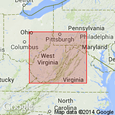
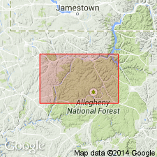
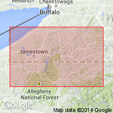
- Areal extent
- AAPG geologic province:
-
- Appalachian basin
Summary:
Authors propose that term Venango be extended to WV in the subsurface, west of the Allegheny Front. Unit has been referred to previously as the "Gordon" sandstone, a thick sequence of amalgamated sandstone in a narrow north-south trending belt in central part of state. Venango here marks the westernmost progradation of Catskill sandstone. It overlies the Greenland Gap Formation and underlies the Riceville. It is not known to crop out anywhere in the state. Age is Late Devonian in this study.
Source: GNU records (USGS DDS-6; Reston GNULEX).
- Usage in publication:
-
- Venango Formation
- Modifications:
-
- Overview
- AAPG geologic province:
-
- Appalachian basin
Summary:
Venango includes all strata from top of upper bounding key bed, the Woodcock Sandstone Member (Venango First sand), to the base of its lower key bed, the Panama Conglomerate Member (Venango Third sand). Formation is about 280 to 330 ft thick in study area. Consists of varying amounts of light-gray conglomerate, conglomeratic sandstone, and sandstone; gray and greenish-gray siltstone; and dark-gray to brownish-gray and minor grayish red shale. Where marker beds are not recognized, contacts are generally mapped by projection of interval thickness. Overlies Chadakoin Formation and underlies Oswayo Formation. Interfingers with Catskill Formation toward the southeast where redbeds begin to dominate. Depositional environment of oil sands interpreted as offshore bar and beach, tidal channels, and subaqueous dunes. Age is Late Devonian.
Source: GNU records (USGS DDS-6; Reston GNULEX).
- Usage in publication:
-
- Venango Group
- Modifications:
-
- Overview
- AAPG geologic province:
-
- Appalachian basin
Summary:
In northern PA, subsurface terminology is informal. The subsurface Venango Group along with the overlying Oswayo Formation, is equivalent to the Conewango Group of NY. Includes lower and upper Red Valley sand/sandstone and Venango First, Second, and Third sands.
Source: GNU records (USGS DDS-6; Reston GNULEX).
For more information, please contact Nancy Stamm, Geologic Names Committee Secretary.
Asterisk (*) indicates published by U.S. Geological Survey authors.
"No current usage" (†) implies that a name has been abandoned or has fallen into disuse. Former usage and, if known, replacement name given in parentheses ( ).
Slash (/) indicates name conflicts with nomenclatural guidelines (CSN, 1933; ACSN, 1961, 1970; NACSN, 1983, 2005, 2021). May be explained within brackets ([ ]).