The National Geologic Map Database is migrating to a new infrastructure. We apologize for any service disruptions during this process.
|
|---|


- Usage in publication:
-
- Valmont dolomite
- Modifications:
-
- Overview
- AAPG geologic province:
-
- Orogrande basin
Summary:
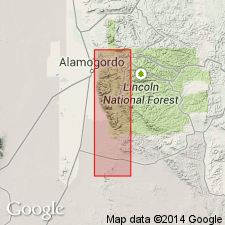
Mapped (geologic map) as an undivided formation along the western escarpment and in the major canyons, Sacramento Mountains, Otero Co, NM in the Orogrande basin. Weathers to a distinctive slope. Lower member ranges from 40 to 70 ft thick. Upper member ranges from 90 to 120 ft thick. Overlies Montoya formation. Underlies Fusselman formation. Columnar section. Probably deposited in shallow, well-aerated water that was not turbulent. Late Ordovician age.
Source: GNU records (USGS DDS-6; Denver GNULEX).
For more information, please contact Nancy Stamm, Geologic Names Committee Secretary.
Asterisk (*) indicates published by U.S. Geological Survey authors.
"No current usage" (†) implies that a name has been abandoned or has fallen into disuse. Former usage and, if known, replacement name given in parentheses ( ).
Slash (/) indicates name conflicts with nomenclatural guidelines (CSN, 1933; ACSN, 1961, 1970; NACSN, 1983, 2005, 2021). May be explained within brackets ([ ]).