- Usage in publication:
-
- Twin Mountains Formation
- Modifications:
-
- Mapped 1:250k
- Dominant lithology:
-
- Claystone
- Sandstone
- Conglomerate
- AAPG geologic province:
-
- Fort Worth syncline
- Strawn basin
Summary:
Twin Mountains Formation. Upper part claystone, middle part sandstone above claystone, lower part mostly sandstone, some claystone and conglomerate. Sandstone, fine- to medium-grained in middle part, medium- to coarse-grained in lower part, sorting best in middle part, friable, locally large scale cross-bedding, mostly light gray, some light brown near middle. Claystone, silty, mostly gray, locally in upper part green, yellow, red. Conglomerate, pebbles of chert and quartz, argillaceous, sandy, gray, brown. Thickness about 150 feet. Lies below Glen Rose Formation and unconformably on Pennsylvanian rocks. Age is Early Cretaceous.
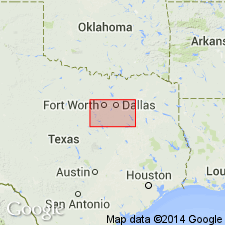
[Mapped in Erath, Hood, Parker, and Somervell Cos., eastern TX.]
Source: Publication.

- Usage in publication:
-
- Twin Mountains Formation
- Modifications:
-
- Mapped 1:250k
- Dominant lithology:
-
- Sand
- Clay
- Conglomerate
- AAPG geologic province:
-
- Fort Worth syncline
Summary:
Pamphlet [p. 6]. Twin Mountains Formation. Sand, clay, and conglomerate; sand, brownish-yellow, locally weathers to red, fine- to coarse-grained, conglomeratic in lower part, thin-bedded to massive, cross-bedded; clay, red, gray, green, silty, thin-bedded to massive; conglomerate composed of chert, quartz, and quartzite clasts. Thickness 175 to 200 feet. [Correlative with lower part of Antlers Sand.] Lies above Permian Petrolia Formation of Wichita Group and below Glen Rose Limestone. Age is Early Cretaceous.
[Mapped southwest of Decatur, in Jack, Parker, and Wise Cos., central northern TX; in southwestern corner of map sheet.]
Source: Publication.
For more information, please contact Nancy Stamm, Geologic Names Committee Secretary.
Asterisk (*) indicates published by U.S. Geological Survey authors.
"No current usage" (†) implies that a name has been abandoned or has fallen into disuse. Former usage and, if known, replacement name given in parentheses ( ).
Slash (/) indicates name conflicts with nomenclatural guidelines (CSN, 1933; ACSN, 1961, 1970; NACSN, 1983, 2005, 2021). May be explained within brackets ([ ]).

