

- Usage in publication:
-
- Trident Member*
- Modifications:
-
- Principal reference
- Dominant lithology:
-
- Shale
- AAPG geologic province:
-
- Montana folded belt
- Sweetgrass arch
- Yellowstone province
Summary:
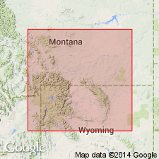
Pg. N2 (fig. 1), N8 (fig. 3), N12-N14; 1962, Billings Geol. Soc. Gdbk., 13th Ann. Field Conf., p. 47-50. Trident Member of Three Forks Formation. Recognized in western Montana and northwesternmost Wyoming. Overlies Logan Gulch Member (new); underlies Sappington Member. At Logan, Montana, member is largely greenish-gray, light-olive-gray, and yellowish-gray calcareous to slightly calcareous fossiliferous clay shale. Thickness 73 feet at Logan. Farther west it ranges from 100 to 225 feet. Extends short distance into northwestern Wyoming. A partly equivalent formal member [Horseshoe Hills] that was proposed by Rau (1962) is disregarded because it includes lower half of Sappington as used by many authors. Trident Member comprises beds that Wilson, 1955 (Billings Geol. Soc. Gdbk. 6th Ann. Field Conf.) considered the restricted Three Forks. Previous usage of name Trident as casually applied by Keyes (Pan-Amer. Geol., v. 46, 1926) is herein abandoned. Age is Late Devonian.
Type section: included in type section of Three Forks, as given by Sandberg (1962), in gulch and on bluffs at north side of Gallatin River, northeast of Logan, in S/2 S/4 sec. 25, T. 2 N., R. 2 E., Gallatin Co., MT. Named from town of Trident on Missouri River about 5 mi northwest of Logan.
[Keyes (Pan-Amer. Geol., v. 46, 1926) applied name Trident to 575 feet of limestones of early Mississippian age in Montana. Origin of name unknown.]
Source: US geologic names lexicon (USGS Bull. 1350, p. 772-773); supplemental information from US geologic names lexicon (USGS Bull. 896, p. 2183).
- Usage in publication:
-
- Trident Member*
- Modifications:
-
- Biostratigraphic dating
- AAPG geologic province:
-
- Montana folded belt
- Central Montana uplift
Summary:
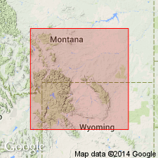
As middle member of Three Forks Formation unconformably underlies the upper tongue of the Cottonwood Canyon Member (new name) of Lodgepole Limestone in southern MT and part of northern MT (Montana folded belt province and Central Montana uplift). To east in northern WY and into west-central WY unconformably underlies the lower tongue of Cottonwood Canyon Member of Madison Limestone. Assigned to the Late Devonian (conodont zone).
Source: GNU records (USGS DDS-6; Denver GNULEX).
- Usage in publication:
-
- Trident Member*
- Modifications:
-
- Areal extent
- AAPG geologic province:
-
- Montana folded belt
Summary:
As middle member [Upper Devonian] of Three Forks Formation, is identified in the Bell-McKenzie Divide section (T11S, R10W), Beaverhead Co, MT in Montana folded belt province.
Source: GNU records (USGS DDS-6; Denver GNULEX).
For more information, please contact Nancy Stamm, Geologic Names Committee Secretary.
Asterisk (*) indicates published by U.S. Geological Survey authors.
"No current usage" (†) implies that a name has been abandoned or has fallen into disuse. Former usage and, if known, replacement name given in parentheses ( ).
Slash (/) indicates name conflicts with nomenclatural guidelines (CSN, 1933; ACSN, 1961, 1970; NACSN, 1983, 2005, 2021). May be explained within brackets ([ ]).