

- Usage in publication:
-
- Torok formation*
- Modifications:
-
- Named
- Biostratigraphic dating
- Dominant lithology:
-
- Silt
- Shale
- Conglomerate
- Graywacke
- AAPG geologic province:
-
- Alaska Northern region
Summary:
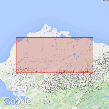
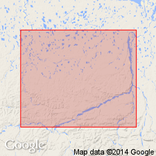
Type locality designated as Torok Creek, tributary to Chandler River in vicinity of Castle Mountain, Southern Foothills [at about 68 deg 34'N, 152 deg 35"W, Chandler Lake quad] northern AK. Well exposed on Chandler and Kiruktagik Rivers in vicinity of Tuktu Bluff about 11 mi north of Castle Mountain. Also widely exposed in east-west belt in Southern Foothills. Comprises 2000 ft of dark silt and clay shale with limestone concretions in lower part and about 8500 ft of dark shale and marine conglomerate and graywacke sandstone in upper part at Castle Mountain. Total thickness at Castle Mountain is 10,500 ft, at Tuktu Bluff, 6000 ft. Unconformably overlies Okpikruak formation (new) at most places. Underlies Nanushuk group; contact believed to be gradational. Contains scarce Aptian and early Albian fauna. Age given as Early Cretaceous.
Source: GNU records (USGS DDS-6; Menlo GNULEX).
- Usage in publication:
-
- Torok formation*
- Modifications:
-
- Revised
- Biostratigraphic dating
- AAPG geologic province:
-
- Alaska Northern region
Summary:
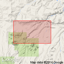
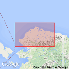
Torok formation of Gryc and others (1951) is redefined to exclude coarse clastic facies of sandstone, conglomerate and intercalated shale sequence that overlies Okpikruak formation and crops out along southern margin of Foothills; these beds now named Fortress Mountain formation (new). Type locality of Torok formation designated as Torok Creek and Chandler River between mouth of Torok Creek and mouth of Kiruktagiak River. Type section (approximately 6000 ft thick) is between 68 deg 40'N and 68 deg 43'45"N along Chandler River and Torok Creek. Fossils indicate late Early Cretaceous age.
Source: GNU records (USGS DDS-6; Menlo GNULEX).
- Usage in publication:
-
- Torok formation*
- Modifications:
-
- Areal extent
- AAPG geologic province:
-
- Alaska Northern region
Summary:
Upper part of Torok formation recognized in subsurface of Grandstand Test Well 1 (68 deg 57'58"N, 151 deg 55'02"W) on Grandstand anticline, 30 mi south of Umiat, Northern Foothills, northern AK. Top surface of Torok reached at depth of 2650 ft. No appreciable lithologic break found between overlying Tuktu formation and Torok. Foraminifers from Torok identified by H.R. Bergquist are listed in report.
Source: GNU records (USGS DDS-6; Menlo GNULEX).
- Usage in publication:
-
- Torok formation*
- Modifications:
-
- Areal extent
- AAPG geologic province:
-
- Alaska Northern region
Summary:
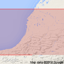
In Utukok-Corwin region unit is exposed in 3- to 12-mile-wide lowland belt that lies along boundary between southern and northern foothills as far west as Ipewik and Kukpuk Rivers. Is about 6458 ft thick. Overlies Fortress Mountain formation and may be in part equivalent to it; underlies Kukpowruk formation with contact gradational and intertonguing. Measured section on Archimedes Ridge anticline, lists of fossils with locations, and geologic map of Utukok-Corwin region included in report.
Source: GNU records (USGS DDS-6; Menlo GNULEX).
- Usage in publication:
-
- Torok Formation*
- Modifications:
-
- Areal extent
- AAPG geologic province:
-
- Alaska Northern region
Summary:
Torok Formation of Early Cretaceous (Albian) age recognized in report area [Umiat-Maybe Creek in southeastern part of Naval Petroleum Reserve No.4, Arctic Slope, northern AK] at expense of Oumalik and overlying Topagoruk Formations of Robinson and others (1956).
Source: GNU records (USGS DDS-6; Menlo GNULEX).
- Usage in publication:
-
- Torok Formation*
- Modifications:
-
- Areal extent
- AAPG geologic province:
-
- Alaska Northern region
Summary:
Isopach map shows extent of Torok Formation in surface and subsurface of National Petroleum Reserve in Alaska and adjacent areas. Is represented on seismic lines by bottomset (basinal), foreset (slope), and topset (shelf) reflectors described as facies of Torok. Rocks formerly called Oumalik Formation now recognized as Torok. Topagoruk Formation is part of highly-transgressive zone between Torok and Nanushuk Group. Names Oumalik and Topagoruk Formations are here abandoned. Torok Formation overlies pebble shale unit in subsurface; overlies Fortress Mountain Formation in southern foothills. Underlies Nanushuk Group. Age remains Early Cretaceous.
Source: GNU records (USGS DDS-6; Menlo GNULEX).
- Usage in publication:
-
- Torok Formation*
- Modifications:
-
- Areal extent
- AAPG geologic province:
-
- Alaska Northern region
Summary:
Pg. 5 (fig. 4), 6-8 (Table 1), 9-11. The Torok Formation, as revised by Patton (1956), is used here. Chiefly dark-gray to black silty shale, mudstone, and clay shale with interbedded thin-bedded siltstone and lesser amounts of greenish-gray, thin-bedded siltstone and fine-grained sandstone. Fine- to medium-grained sandstone common in lower part. Southern outcrop belt 18,500+ feet thick, thins to <3,100 feet beneath northern Arctic Coastal Plain. Fossils. Age is Early to early Late Cretaceous (Aptian to Cenomanian); the Torok becomes younger from west to east. Type section stated.
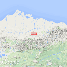
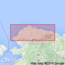
Type section of Patton (1956): approx. 6,000 ft section along Torok Creek and Chandler River [between approx. Lat. 68 deg. 40 min. and 68 deg. 44 min. 30 sec. N., in northwestern Chandler Lake C-4 quadrangle, scale 1:63,360, Alaska-North Slope Borough], northern AK; lower part along Torok Creek, in secs. 2, 3, 4, and 9, T. 9 S., R. 2 W., and continues up-section along Chandler River, in secs. 1 and 2, T. 9 S., R. 2 W., and in secs. 23, 25, and 36, T. 8 S., R. 2 W.
Source: Publication.
For more information, please contact Nancy Stamm, Geologic Names Committee Secretary.
Asterisk (*) indicates published by U.S. Geological Survey authors.
"No current usage" (†) implies that a name has been abandoned or has fallen into disuse. Former usage and, if known, replacement name given in parentheses ( ).
Slash (/) indicates name conflicts with nomenclatural guidelines (CSN, 1933; ACSN, 1961, 1970; NACSN, 1983, 2005, 2021). May be explained within brackets ([ ]).