The National Geologic Map Database is migrating to a new infrastructure. We apologize for any service disruptions during this process.
|
|---|


- Usage in publication:
-
- Topanga Canyon Formation*
- Modifications:
-
- Named
- Dominant lithology:
-
- Sandstone
- Siltstone
- AAPG geologic province:
-
- Transverse Ranges province
Summary:
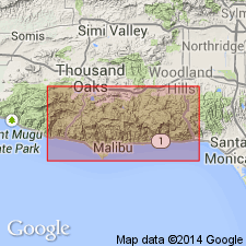
Type locality: "Topanga Canyon fauna" locality, roadcuts on Old Topanga Road, SW/4 sec.35 T1N R17W, Santa Monica Mountains, northeast corner Malibu Beach quad, Los Angeles Co, CA. Named for Topanga Canyon which is southeast of type locality. Is lowest of three formations in Topanga Group. Is undivided between Trancas and Malibu Canyons; west of Trancas Canyon includes Encinal Member; east of Malibu canyon includes (ascending) Saddle Peak, Fernwood, and Cold Creek Members. Consists of biotitic sandstone, siltstone, and pebbly sandstone. Is divided into marine, nearshore marine, and nonmarine facies. Is 675 m thick where undivided. Conformably overlies Vaqueros Formation or Sespe Formation; underlies Conejo Volcanics (Topanga Group) or, locally, underlies Calabasas Formation (Topanga Group). Is middle Miocene age.
Source: GNU records (USGS DDS-6; Menlo GNULEX).
For more information, please contact Nancy Stamm, Geologic Names Committee Secretary.
Asterisk (*) indicates published by U.S. Geological Survey authors.
"No current usage" (†) implies that a name has been abandoned or has fallen into disuse. Former usage and, if known, replacement name given in parentheses ( ).
Slash (/) indicates name conflicts with nomenclatural guidelines (CSN, 1933; ACSN, 1961, 1970; NACSN, 1983, 2005, 2021). May be explained within brackets ([ ]).