The National Geologic Map Database is migrating to a new infrastructure. We apologize for any service disruptions during this process.
|
|---|


- Usage in publication:
-
- Tokio sand member
- Modifications:
-
- Named
- Dominant lithology:
-
- Sand
- AAPG geologic province:
-
- Arkla basin
- Ouachita folded belt
Summary:
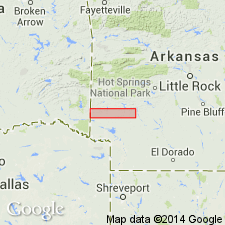
Adopted as defined and named by Miser and Purdue (1918) as the upper member of Bingen formation. Named for the village of Tokio, Hempstead Co, AR. Shown to occur as mapped in Ts 7, 8, 9S, Rs 24, 25, 26W, Hempstead and Pike Cos, AR in the Arkla basin and Ouachita tectonic belt province. Is noted to be the only part of Bingen formation exposed east of Little Missouri River in study area. Formerly included in Bingen sand of Veatch (1906), which is here revised. Contains sand and clay, in addition to a basal gravel and three higher gravels. Sand is cross bedded, incoherent, firmly packed gray quartz sand in beds, some exceeding 30 ft thick; contains disseminated kaolin particles and a few scattered pebbles; becomes red upon weathering and produces gray sandy soil. Light- and dark-colored clays interbedded with sand; some contain fossil plants and small quantities of iron pyrites and lignitiferous matter. Light-colored clays occur in beds as much as 6 ft thick consisting of plastic clay balls and nonplastic kaolins. Comprises upper 100-150 ft of Bingen formation. Basal gravel marks the contact with underlying unnamed lower member of Bingen formation. Contact with overlying Brownstown marl is gradational. Assigned to the Upper Cretaceous.
Source: GNU records (USGS DDS-6; Denver GNULEX).
- Usage in publication:
-
- Tokio Formation*
- Modifications:
-
- Overview
- Areal extent
- AAPG geologic province:
-
- Arkla basin
Summary:
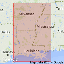
Underlies Brownstown Formation conformably. Overlies Eagle Ford Formation conformably where the latter unit is present in the study area. Unconformably overlies undifferentiated Lower Cretaceous strata on the summit of the Sabine uplift, particularly on the local positive structural anomaly known as the Caddo-Pine Island uplift. Maximum thickness of 620 ft noted in southeastern Caddo Parish, LA. Is subdivided into four informal units (in ascending order): 1) lower Tokio unit (200-300 ft; interbedded marls, shales, silts, and chalks), 2) middle Tokio unit (150-250 ft; quartzose, fine- to medium-grained sands with some chert pebbles interbedded with dark gray shales; sands 8-55 ft thick), 3) Trees City sand (maximum thickness of 150 ft and thinning abruptly southward as it changes facies into shale; medium-grained quartz sand with some interbedded gray shale; includes as much as 8 ft of shale separating it from the overlying Roberson sand), and 4) Roberson sand (10-30 ft thick in northern Caddo Parish, increasing southward to 198 ft; thinly bedded silts, fine- to coarse-grained sand and calcareous shales; thins and merges with Trees City sand northward in AR). Representative subsurface sections for each unit are designated and well logs provided as illustrations. [Trees City and Roberson sands are probably equivalent in total or in part to Blossom Sand.]
Source: GNU records (USGS DDS-6; Denver GNULEX).

- Usage in publication:
-
- Tokio Formation
- Modifications:
-
- Mapped 1:250k
- Dominant lithology:
-
- Sand
- Clay
- Gravel
- AAPG geologic province:
-
- Arkla basin
- Ouachita folded belt
Summary:
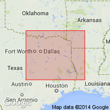
Tokio Formation. Quartz sand, clay, and gravel. In upper part sand, fine- to coarse-grained, friable, in part argillaceous, some interbeds of light- and dark-gray clay, cross-bedded to massive, some beds about 30 feet thick, gray to light-brown; weathers various shades of yellow, red, and brown. In lower part clay, in part sandy, increasingly more sandy eastward, lignitic, dark-gray; abundant plant fragments, a few marine megafossils. Gravel in lower 10 to 20 feet mostly novaculite, some quartz, quartzite, and sandstone. Thickness 300 to 530 feet, thins eastward. [Upper part correlative with Blossom Sand, and lower part correlative with Bonham Formation (both of Texas).] Lies above Eagle Ford Formation and below Brownstown Marl. Age is Late Cretaceous.
[Mapped in northeastern part of map sheet, north of Red River, in McCurtain Co., southeastern OK, and Little River, Sevier, and Howard Cos., southwestern AR. Not mapped in TX.]
Source: Publication.
- Usage in publication:
-
- Tokio Formation*
- Modifications:
-
- Paleomagnetics
- AAPG geologic province:
-
- Ouachita folded belt
Summary:
Paleomagnetic (a.f. demagnetized) data indicates the Upper Cretaceous Tokio Formation in the Ouachita tectonic belt province in southwest AR possesses a weak remanent magnetization of normal magnetic polarity. The normal polarity is assumed to be primary magnetization, and is interpreted to represent deposition during the Gubbio (Italy) long normal zone (Santonian and older).
Source: GNU records (USGS DDS-6; Denver GNULEX).
For more information, please contact Nancy Stamm, Geologic Names Committee Secretary.
Asterisk (*) indicates published by U.S. Geological Survey authors.
"No current usage" (†) implies that a name has been abandoned or has fallen into disuse. Former usage and, if known, replacement name given in parentheses ( ).
Slash (/) indicates name conflicts with nomenclatural guidelines (CSN, 1933; ACSN, 1961, 1970; NACSN, 1983, 2005, 2021). May be explained within brackets ([ ]).