The National Geologic Map Database is migrating to a new infrastructure. We apologize for any service disruptions during this process.
|
|---|


- Usage in publication:
-
- Tinton beds
- Modifications:
-
- Named
- Dominant lithology:
-
- Sand
- AAPG geologic province:
-
- Atlantic Coast basin
Summary:
Tinton beds, exposed at Tinton Falls, NJ, are composed of hard glauconitic, indurated sand, 22 ft thick. For faunal and stratigraphic reasons it is separated from underlying Redbank sand and recognized as a distinct formation. Fauna is more closely allied to beds below than to beds above. Underlies Sewell [Hornerstown] marl. Was included in Red Sand of Cook.
Source: GNU records (USGS DDS-6; Reston GNULEX).
- Usage in publication:
-
- Tinton member
- Modifications:
-
- Revised
- Areal extent
- AAPG geologic province:
-
- Atlantic Coast basin
Summary:
Tinton is reallocated to member status in the Monmouth, herein reduced to formational rank. Conformably overlies Red Bank member; conformably underlies Hornerstown formation. Where best developed in Monmouth Co., reaches maximum thickness of 25 ft. Dips about 20 ft per mile southeast and cannot be recognized south of Red Valley in southern part of county.
Source: GNU records (USGS DDS-6; Reston GNULEX).
- Usage in publication:
-
- Tinton Formation*
- Modifications:
-
- Revised
- AAPG geologic province:
-
- Atlantic Coast basin
Summary:
Tinton Sand Member of Red Bank Sand raised to formation rank. Monmouth Group now consists of (ascending) Mount Laurel Sand, Navesink Formation, Red Bank Sand, and Tinton Sand.
Source: GNU records (USGS DDS-6; Reston GNULEX).
- Usage in publication:
-
- Tinton Formation
- Modifications:
-
- Overview
- AAPG geologic province:
-
- Atlantic Coast basin
Summary:
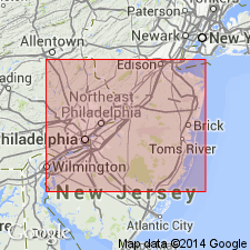
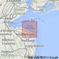
Tinton Formation of Monmouth Group is a light to moderate yellowish or reddish brown poorly sorted medium to coarse grained glauconitic quartz sandstone cemented by siderite that reaches a maximum thickness of 7.5 m. Maastrichtian zone fossil SPHENODISCUS LOBATUS and various other mollusks occur in the Tinton. The most common fossils, however, are the claws of the decapod crustacean CALLIANASSA MORTONI Pillsbury. The Tinton is restricted to Monmouth Co., extending from Sandy Hook in the northeast to Roosevelt in the southwest. Exposures are found at Beers Hill in Holmdel and at Tinton Falls. Overlies the Red Bank Formation and underlies the Hornerstown. Merges with the New Egypt Formation downdip. Age is late Maastrichtian according to Olsson (1989).
Source: GNU records (USGS DDS-6; Reston GNULEX).
- Usage in publication:
-
- Tinton Formation
- Modifications:
-
- Overview
- AAPG geologic province:
-
- Atlantic Coast basin
Summary:
The Maastrichtian unconformity-bounded sequence in the NJ coastal plain, here informally termed the Navesink sequence, includes the Navesink Formation, the Sandy Hook and Shrewsbury Members of the Red Bank Formation, and the Tinton Formation and ranges in age from 69.3 to 65 Ma based on Sr-isotope age estimates. Sequence is assigned to the calcareous nannofossil Zones CC20/21 and CC22b. High sedimentation rates in the latest Maastrichtian of NJ suggest tectonic uplift and/or rapid progradation during deposition of the highstand systems tract. The unconformable contact with the Campanian Mount Laurel Formation of the underlying Marshalltown sequence is marked by a reworked zone of a pebbly, poorly sorted, glauconite-quartz sand. The Navesink Formation is the transgressive, basal, clayey glauconite sand in a coarsening-upward sedimentary sequence. It is interpreted to be a middle-shelf deposit with large beds of calcareous shells dispersed throughout. The overlying Sandy Hook Member of the Red Bank is a massive, dark-gray, micaceous, fossiliferous, clayey silt and fine sand that grades upward into the Shrewsbury Member, a burrowed, slightly glauconitic, medium to coarse quartz sand that is unfossiliferous because of leaching. The sequence changes dramatically to the southwest along the outcrop belt. The Shrewsbury Member pinches out near New Egypt; the Sandy Hook changes from clayey fine sand to glauconite sand and pinches out several mi to the west of New Egypt, and the Navesink Formation thins or is locally absent. The Tinton Formation, uppermost Maastrichtian unit in NJ, crops out in a northern belt extending from the Atlantic Highlands southwestward to Perrineville and reaches a maximum thickness of 11 m just west of its type section. The Tinton is an unconsolidated to well-indurated, clayey, feldspathic, glauconite-quartz sand. The sequence unconformably underlies the Hornerstown Formation, dated as either Maastrichtian and early Paleocene or entirely early Paleocene.
Source: GNU records (USGS DDS-6; Reston GNULEX).
- Usage in publication:
-
- Tinton Formation*
- Modifications:
-
- Geochronologic dating
- AAPG geologic province:
-
- Atlantic Coast basin
Summary:
The Tinton Formation in NJ consists of hard, siderite-cemented, reddish-brown to dark-gray quartz-glauconite sand. Unit was extremely dissected prior to deposition of overlying Hornerstown Formation. Unit only occurs in northern New Jersey Coastal Plain. Overlies the Red Bank Formation. Strontium isotopic analysis of calcareous shells from the Tinton indicate a late Maastrichtian (66.2 to 65.6 Ma) age.
Source: GNU records (USGS DDS-6; Reston GNULEX).
For more information, please contact Nancy Stamm, Geologic Names Committee Secretary.
Asterisk (*) indicates published by U.S. Geological Survey authors.
"No current usage" (†) implies that a name has been abandoned or has fallen into disuse. Former usage and, if known, replacement name given in parentheses ( ).
Slash (/) indicates name conflicts with nomenclatural guidelines (CSN, 1933; ACSN, 1961, 1970; NACSN, 1983, 2005, 2021). May be explained within brackets ([ ]).