

- Usage in publication:
-
- Thunder Springs Member*
- Modifications:
-
- Named
- Dominant lithology:
-
- Dolomite
- Chert
- Limestone
- AAPG geologic province:
-
- Plateau sedimentary province
Summary:
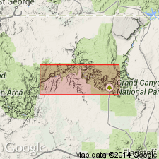
Named as one of four members of Redwall Limestone. Type section is in cliff west of springs at head of Thunder River [not precisely located] about 2 mi north of Colorado River, Grand Canyon, AZ in the Plateau sedimentary province. Is a dolomite and bedded chert unit east of Grand Canyon; is a limestone and bedded chert unit in the western part of the Grand Canyon. Grains within the limestone range from fine to very coarse, and consist of bioclasts and peloids in an aphanitic calcite matrix. Overlies Whitmore Wash Member (new) of Redwall; unconformably underlies Mooney Falls Member (new) of Redwall. Assigned to the Mississippian.
Source: GNU records (USGS DDS-6; Denver GNULEX).
- Usage in publication:
-
- Thunder Springs Member*
- Modifications:
-
- Areal extent
- AAPG geologic province:
-
- Plateau sedimentary province
Summary:
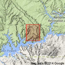
The name Redwall Limestone of Early and Late Mississippian age is extended northward from AZ into Kane Co, UT in the Plateau sedimentary province. Redwall unconformably overlies the Upper Devonian and Lower Mississippian Ouray? Limestone and unconformably underlies the Lower Pennsylvanian Molas Formation. The formation is divided in three parts (ascending): 1) Whitmore Wash and Thunder Springs Members, 232 ft thick; 2) Mooney Falls Member, 289 ft thick; and 3) Horseshoe Mesa Member, 160 ft thick. The Whitmore Wash and Thunder Springs are white, fossiliferous dolomite with white tripolitic chert. The Mooney Falls is a white to brown, crinoidal, cherty dolomite with a few thin brown limestone beds. The Horseshoe Mesa is a brown to white limestone with chert, and algal structures. The Early-Late Mississippian boundary lies within Mooney Falls Member. A marine deposit.
Source: GNU records (USGS DDS-6; Denver GNULEX).
- Usage in publication:
-
- Thunder Springs Member*
- Modifications:
-
- Areal extent
- Overview
- AAPG geologic province:
-
- Black Mesa basin
Summary:
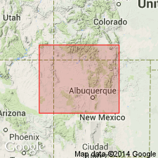
Redwall Limestone identified in subsurface of Black Mesa basin of northeast AZ where it can be divided into (ascending): Whitmore Wash Member (Kinderhookian and Osagean), Thunder Springs Member (Osagean), Mooney Falls Member (Osagean), and an upper or limestone unit (Meramecian). The Whitmore Wash unconformably overlies Devonian Martin Formation. The Mooney Falls is separated from the upper limestone unit by an unconformity. The end of Osagean is marked by a regional hiatus. The Meramecian-age limestone unit may be part of or equivalent to part of the Mooney Falls Member to the west or to the younger Horseshoe Member of the Redwall. The Redwall is overlain unconformably by unnamed redbeds and residuum. Correlation chart. The Whitmore Wash to Mooney Falls Members shown as equivalent to the lower part of the Leadville Limestone, and the Meramecian undesignated part of the Redwall is shown as equivalent to the upper part of the Leadville of the San Juan basin subsurface of northwest NM.
Source: GNU records (USGS DDS-6; Denver GNULEX).
For more information, please contact Nancy Stamm, Geologic Names Committee Secretary.
Asterisk (*) indicates published by U.S. Geological Survey authors.
"No current usage" (†) implies that a name has been abandoned or has fallen into disuse. Former usage and, if known, replacement name given in parentheses ( ).
Slash (/) indicates name conflicts with nomenclatural guidelines (CSN, 1933; ACSN, 1961, 1970; NACSN, 1983, 2005, 2021). May be explained within brackets ([ ]).