

- Usage in publication:
-
- Templeton member*
- Modifications:
-
- Named
- Mapped 1:63k
- Dominant lithology:
-
- Shale
- Sand
- AAPG geologic province:
-
- South Oklahoma folded belt
- Ouachita folded belt
- Fort Worth syncline
Summary:
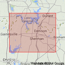
Named as top member of Woodbine formation. Type section exposed in gullied pasture and in bluffs along Templeton Branch, 0.2-0.4 mi west of country Rd corner and 0.5-0.65 mi west of the Bells-Ambrose Rd, centering about 2.6 mi north and 0.2 mi east of Hwy 69 underpass of TX and Pacific RR at Bells, Grayson Co, TX in South Oklahoma folded belt province. Mapped in Grayson Co; Denton Co, TX in Fort Worth syncline; and in Fannin Co, TX in Ouachita tectonic belt province. Moreman (1942) included the interval in his Tarrant formation of Eagle Ford age. Lithology and faunas indicate this sequence of sedimentary rocks is more closely related to Woodbine formation than to Eagle Ford shale. Is fossiliferous, largely smooth gray shale with lenses of glauconitic gray and tan soft sand; numerous limy concretions occur in both sand and shale. Lower part characterized by a few ft of tan tuffaceous clay in northeastern Grayson Co and adjacent Fannin Co. Is 70-80 ft thick. Overlies Lewisville member of Woodbine; underlies Eagle Ford shale (alunite nodules conspicuous at upper contact). Fossils include ammonites, gastropods, bivalves, and arenaceous foraminifers. Correlation of columnar sections. Structure contour maps on base and top of Woodbine. Isopach map of Woodbine. Age is Late Cretaceous.
Source: GNU records (USGS DDS-6; Denver GNULEX).
- Usage in publication:
-
- Templeton Member*
- Modifications:
-
- Biostratigraphic dating
- AAPG geologic province:
-
- South Oklahoma folded belt
Summary:
Is top member of Woodbine Formation in north TX. Is assigned a late middle or early late Cenomanian (Late Cretaceous) age based on presence of the ammonite EUCALYCOCERAS TEMPLETONENSE from silty limestone concretions 6.0-6.7 m above base of member at USGS locality 20314 north of Bells, Grayson Co, TX in the South Oklahoma folded belt province. Fauna places unit in either the PLEISIACANTHOCERAS WYOMINGENSE (late middle Cenomanian) zone or the DUNVEGANOCERAS PONDI zone (early late Cenomanian).
Source: GNU records (USGS DDS-6; Denver GNULEX).

- Usage in publication:
-
- Templeton Member
- Modifications:
-
- Mapped 1:250k
- Dominant lithology:
-
- Shale
- Sand
- AAPG geologic province:
-
- Ouachita folded belt
- South Oklahoma folded belt
Summary:
Pamphlet [p. 4]. Templeton Member of Woodbine Formation. In Texas, shale, gray, glauconitic, some lenses of gray to yellowish-brown sand, marine megafossils; thickness 70 to 80 feet. In Oklahoma, shale, dark-gray, weathers to brown, iron-stained, some beds of yellow sandstone and clay ironstone, phosphatic nodules and calcareous concretions common; thickness 60 to 70 feet. Top member of Woodbine Formation. Lies above Lewisville Member of Woodbine Formation and below Eagle Ford Formation. Age is Late Cretaceous.
[Mapped in mostly continuous belts on either side of Red River and southward to Lake Ray Roberts (Tioga area); in Fannin and Grayson Cos., northeastern TX, and Bryan Co., southeastern OK; northeastern and central part of map sheet.]
Source: Publication.
For more information, please contact Nancy Stamm, Geologic Names Committee Secretary.
Asterisk (*) indicates published by U.S. Geological Survey authors.
"No current usage" (†) implies that a name has been abandoned or has fallen into disuse. Former usage and, if known, replacement name given in parentheses ( ).
Slash (/) indicates name conflicts with nomenclatural guidelines (CSN, 1933; ACSN, 1961, 1970; NACSN, 1983, 2005, 2021). May be explained within brackets ([ ]).