

- Usage in publication:
-
- Temple Cap member*
- Modifications:
-
- Named
- Dominant lithology:
-
- Sandstone
- Limestone
- Conglomerate
- AAPG geologic province:
-
- Great Basin province
Summary:
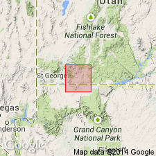
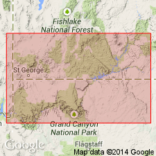
Named as the upper and readily distinguished member of the Navajo sandstone of the Glen Canyon group for features called East Temple and West Temple in Zion Park, Washington Co, UT in the Great Basin province. Formerly assigned to Carmel formation. No type locality designated. Divisible into a lower part 6 to 30 ft thick composed of irregularly bedded, red, gray, or brown, shaly, calcareous sandstone; siliceous limestone and limestone conglomerate; and an upper part 70 to 180 ft thick of red, tan, white, yellow (banded appearing), cliff-forming, massive, strongly cross-bedded sandstone, much like the main part of the Navajo. Sandstone in upper part is composed of uniformly rounded, clean quartz grains weakly cemented by lime and iron. Overlies main part of Navajo. Unconformably underlies Carmel formation. Mapped (geologic map) with Navajo. Not present everywhere. At some places, Carmel rests on main part of Navajo. East of Kanab Canyon, lower part becomes thicker and more calcareous, and upper part becomes thinner, less massive, and more varied in composition. Of fluvial and eolian origin. Of Jurassic age.
Source: GNU records (USGS DDS-6; Denver GNULEX).
- Usage in publication:
-
- Temple Cap member*
- Modifications:
-
- Overview
- AAPG geologic province:
-
- Plateau sedimentary province
Summary:
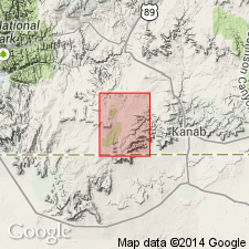
Temple Cap member, upper member of Navajo sandstone, mapped along west-central and northwest part of quad, Kane Co, UT in the Plateau sedimentary province west of the Sevier fault. Member overlies main body of Navajo and underlies Carmel formation. Assigned a Jurassic? and Jurassic age.
Source: GNU records (USGS DDS-6; Denver GNULEX).
- Usage in publication:
-
- Temple Cap Tongue
- Modifications:
-
- Contact revised
- AAPG geologic province:
-
- Plateau sedimentary province
Summary:
Upper contact revised in that Temple Cap Tongue (or Member) of Navajo Sandstone of Glen Canyon Group underlies the newly named Kolob Limestone Member of the Carmel Formation of the San Rafael Group in Kane Co, UT, Plateau sedimentary province. Cross sections. Block diagrams. In Zion Canyon and east to White Cliffs, southeast of Mount Carmel Junction, Temple Cap is well defined; it is separated from the main mass of Navajo by a red silty tongue of Carmel. East of Kanab Creek, where the red silty tongue is missing, Temple Cap cannot be separated from main part of Navajo. At Mount Carmel Junction and westward, Temple Cap is separated from Kolob by a thin gypsiferous red siltstone and shale of the Carmel. Jurassic age.
Source: GNU records (USGS DDS-6; Denver GNULEX).
- Usage in publication:
-
- Temple Cap Sandstone*
- Modifications:
-
- Principal reference
- Revised
- Dominant lithology:
-
- Sandstone
- AAPG geologic province:
-
- Plateau sedimentary province
- Great Basin province
Summary:
Previously thought to grade into the Navajo Sandstone east of Mount Carmel Junction, Kane Co, UT. Considered to be a separate unit from Navajo and not gradational into Navajo in this report. Principal reference section designated at NW1/4 NW1/4 sec 2, T41S, T10W, Washington Co, UT, Great Basin province, a section that is designated the type section for its two newly named members, the Sinawava and White Throne Members. Is known only in southwest UT where it occurs between the Navajo and Carmel Formation and as basal formation of San Rafael Group. Is 55.8 m thick at principal reference section. Is 113.4 m thick near Gunlock, UT. Thins eastward to its wedgeout near Johnson Canyon, Kane Co, UT, Plateau sedimentary province. The upper and lower contacts are unconformities. Members composed of gray, very fine to fine-grained sandstone. An interbedded sandstone and dark reddish-brown, laminated to very thin bedded mudstone at top of Sinawava separates it from the overlying White Throne. Assigned an early and middle Bajocian, or Middle Jurassic age.
Source: GNU records (USGS DDS-6; Denver GNULEX).
- Usage in publication:
-
- Temple Cap Formation*
- Modifications:
-
- Redescribed
- Dominant lithology:
-
- Sandstone
- Siltstone
- AAPG geologic province:
-
- Great Basin province
Summary:
Rank term "Sandstone" modified to "Formation" in report area. Temple Cap described as a red and white sandstone and siltstone unit that lies conformably above the Navajo Sandstone and beneath the Claron Formation. These rocks were assigned to the Carmel Formation by earlier authors. Is about 390 m thick. Siltstone occurs as interbeds in the lowest 60 m. The overlying 150 m is red, silty sandstone and tan, fine-grained, flaggy, ledge- and slope-forming sandstone. The upper 180 m is cliff-forming, medium-grained tan sandstone with small scale water-laid crossbeds. Middle Jurassic age. Mapped in a small area in north-central part of quad.
Source: GNU records (USGS DDS-6; Denver GNULEX).
For more information, please contact Nancy Stamm, Geologic Names Committee Secretary.
Asterisk (*) indicates published by U.S. Geological Survey authors.
"No current usage" (†) implies that a name has been abandoned or has fallen into disuse. Former usage and, if known, replacement name given in parentheses ( ).
Slash (/) indicates name conflicts with nomenclatural guidelines (CSN, 1933; ACSN, 1961, 1970; NACSN, 1983, 2005, 2021). May be explained within brackets ([ ]).