

- Usage in publication:
-
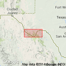
- Telephone Canyon Formation
- Modifications:
-
- Mapped 1:250k
- Dominant lithology:
-
- Limestone
- AAPG geologic province:
-
- Permian basin
Summary:
Telephone Canyon Formation. Not separately mapped. Mapped (undifferentiated) with Santa Elena Limestone, Sue Peaks Formation, and Del Carmen Limestone in Brewster, and Presidio Counties, Texas. Consists of limestone, nodular, marly, yellowish-gray to brownish-gray, yellowish marl partings increase in number downward; marine megafossils common; forms slope at base of Del Carmen Limestone cliffs. Thickness about 75 feet in Big Bend National Park. Overlies Maxon Sandstone in vicinity of Santiago Mountains and central Brewster County; overlies Glen Rose Formation southward where Maxon has feathered out. Underlies Del Carmen Limestone. Age is Early Cretaceous.
Source: Publication; supplemental information from GNU records (USGS DDS-6; Denver GNULEX).
For more information, please contact Nancy Stamm, Geologic Names Committee Secretary.
Asterisk (*) indicates published by U.S. Geological Survey authors.
"No current usage" (†) implies that a name has been abandoned or has fallen into disuse. Former usage and, if known, replacement name given in parentheses ( ).
Slash (/) indicates name conflicts with nomenclatural guidelines (CSN, 1933; ACSN, 1961, 1970; NACSN, 1983, 2005, 2021). May be explained within brackets ([ ]).