The National Geologic Map Database is migrating to a new infrastructure. We apologize for any service disruptions during this process.
|
|---|


- Usage in publication:
-
- Swearinger slates
- Modifications:
-
- First used
- Biostratigraphic dating
- Dominant lithology:
-
- Slate
- AAPG geologic province:
-
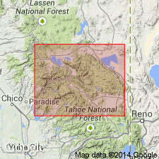
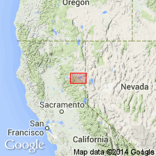
- Sierra Nevada province
Summary:
Geologic column of Taylorville [Taylorsville] region shows Swearinger slates includes MONOTIS [zone of PSEUDOMONOTIS SUBCIRCULARIS], RHABOCERAS, and HALOBIA beds (of Alpheus Hyatt), is 200 ft thick, and is Late Triassic (late Noric) in age. Consists of dark, calcareous slate with thin blue limestone and some siliceous layers. Unconformably overlies the Carboniferous Robinson beds. Believed to underlie the Hosselkus limestone.
Source: GNU records (USGS DDS-6; Menlo GNULEX).
- Usage in publication:
-
- Swearinger slate
- Modifications:
-
- Named
- Dominant lithology:
-
- Shale
- AAPG geologic province:
-
- Sierra Nevada province
Summary:
[Named] for fact that Swearinger slate occurs just above Swearinger's house and spring on north side of Genesee Valley, Plumas Co., CA. Best exposure is on "Triassic spur". Outcrop in Taylorsville region limited along strike to distance of less than 3 mi and width where greatest of about a third of a mi. Consists chiefly of dark slaty shale, sometimes more or less calcareous, and at other times decidedly siliceous, but thin beds of limestone or chert form only small portion of whole mass. The thin lenticular limestone beds become more abundant in side adjoining Hosselkus limestone. Beds are generally dark, with irregular cherty or sandy layers and fossiliferous. Thickness is 200 ft. Is underlain (not overlain as originally supposed) by the Hosselkus limestone with which it is conformable, but in places rests on the older Robinson formation. Is overlapped by the Trail formation.
Source: GNU records (USGS DDS-6; Menlo GNULEX).
- Usage in publication:
-
- Swearinger Slate, Formation
- Modifications:
-
- Overview
- AAPG geologic province:
-
- Sierra Nevada province
Summary:
Late Triassic Hosselkus Limestone and Swearinger Formation [Slate] are exposed in Taylorsville area only on frontal margin of upper plate of Taylorsville thrust. Both are overturned and may be referred to as the Triassic sequence which has preserved thickness of only 1100 ft. Upper boundary of sequence is trace of Taylorsville thrust and is locally cut out by granitic pluton. Contact between the Hosselkus Limestone and Swearinger Slate is gradational. Swearinger is perhaps 900 ft in thickness. Upper part of Swearinger contains considerable hornfelsed feldspathic sandstone that could mark the base of the Jurassic.
Source: GNU records (USGS DDS-6; Menlo GNULEX).
For more information, please contact Nancy Stamm, Geologic Names Committee Secretary.
Asterisk (*) indicates published by U.S. Geological Survey authors.
"No current usage" (†) implies that a name has been abandoned or has fallen into disuse. Former usage and, if known, replacement name given in parentheses ( ).
Slash (/) indicates name conflicts with nomenclatural guidelines (CSN, 1933; ACSN, 1961, 1970; NACSN, 1983, 2005, 2021). May be explained within brackets ([ ]).