

- Usage in publication:
-
- Sulphur Flats Sandstone Member*
- Modifications:
-
- Named
- Dominant lithology:
-
- Sandstone
- AAPG geologic province:
-
- Montana folded belt
Summary:
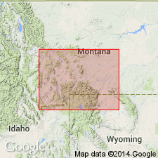
Named as basal member of Miner Creek Formation (new) of Livingston Group (rank raised) for exposures along Miner Creek near Sulphur Flats in SE1/4 sec 19, T2S, R9E (also the type section), Park Co, MT, Montana folded belt province. Is a prominent ridge-forming sandstone and tuff 160 ft thick. Overlies Cokedale Formation (new) of Livingston Group and underlies upper part of Miner Creek. Is a massive, cross-bedded, poorly sorted sandstone containing biotite, diopside, plagioclase, augite, hornblende, and magnetite. Tuff and bentonite interbedded near base. Petrified wood, pollen, spores, and dinosaur bones also present. Equivalent to Lennep Sandstone to north. Is of Late Cretaceous, Campanian age. Correlation chart.
Source: GNU records (USGS DDS-6; Denver GNULEX).
- Usage in publication:
-
- Sulphur Flats Sandstone Member*
- Modifications:
-
- Overview
- AAPG geologic province:
-
- Montana folded belt
Summary:
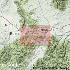
Measured section of Sulphur Flats Sandstone Member, basal member of Miners Creek Formation of Livingston Group, described in NW1/4 sec 20 and E1/2 sec 19, T2S, R9E, Park Co, MT in Montana folded belt province. This section is type for Miners Creek. Is 160 ft thick at section where it overlies Cokedale Formation of Livingston and underlies upper part of Miners Creek. Consists of: 1) sandstone that may be yellow, olive to green gray, fine to coarse grained, thin to thick bedded to massive or cross-bedded, poorly sorted, well indurated, andesitic; 2) tuff that may be gray green, thin to medium bedded, well indurated; and 3) siltstone that may be light gray to olive, green to dark gray, tuffaceous, well indurated, thin, medium to thick bedded. Basal and top beds are distinctly different from other sandstone beds of Livingston. Basal bed is fine-grained, calcareous, mottled yellow-gray sandstone 6-20 ft thick. Top sandstone bed is a ridge-former, well indurated with subangular volcanic rock fragments and lesser amounts of plagioclase. Of Late Cretaceous, late Campanian age. Correlation chart. Geologic map.
Source: GNU records (USGS DDS-6; Denver GNULEX).
For more information, please contact Nancy Stamm, Geologic Names Committee Secretary.
Asterisk (*) indicates published by U.S. Geological Survey authors.
"No current usage" (†) implies that a name has been abandoned or has fallen into disuse. Former usage and, if known, replacement name given in parentheses ( ).
Slash (/) indicates name conflicts with nomenclatural guidelines (CSN, 1933; ACSN, 1961, 1970; NACSN, 1983, 2005, 2021). May be explained within brackets ([ ]).