

- Usage in publication:
-
- Sugarlump Tuffs*
- Modifications:
-
- Overview
- AAPG geologic province:
-
- Basin-and-Range province
Summary:
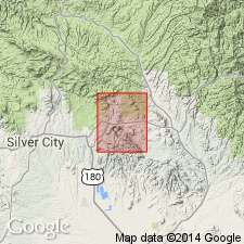
Consists of several volcanic and clastic units: well-bedded and massive pyroclastic latitic or rhyolitic deposits, volcanic conglomerates, and sandstone. Is disconformable on Rubio Peak Formation. Conformably overlain by Kneeling Nun Tuff. Deposited on an uneven surface, so thickness varies; is 50-800 ft thick in quad, up to 1,300 ft elsewhere. Assigned a Miocene? age. Mapped in the southern part of the quad in Grant Co, NM in the Basin-and-Range province.
Source: GNU records (USGS DDS-6; Denver GNULEX).
- Usage in publication:
-
- Sugarlump Tuff*
- Modifications:
-
- Redescribed
- Overview
- Dominant lithology:
-
- Tuff
- Sandstone
- AAPG geologic province:
-
- Basin-and-Range province
Summary:
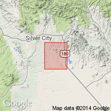
Stratigraphic rank term modified from Sugarlump Tuffs to Sugarlump Tuff. Described in this quad as consisting of light- to medium-gray rhyolite tuffs that are interbedded with poorly to well-bedded, cream to gray, tuffaceous sandstone and conglomerate. Some of the tuffs are light and porous; some are dense. Section 530 ft thick measured just east of the quad in sec 19, T18S, R12W. Overlies Rubio Peak Formation. Underlies Kneeling Nun Tuff. Two units mapped in northeast corner of quad--the tuffs and the tuffaceous sandstones. Map area is in the Basin-and-Range province. Assigned a Miocene? age, but it could be as old as late Oligocene and as young as early Pliocene.
Source: GNU records (USGS DDS-6; Denver GNULEX).
- Usage in publication:
-
- Sugarlump Tuff*
- Modifications:
-
- Age modified
- AAPG geologic province:
-
- Basin-and-Range province
Summary:
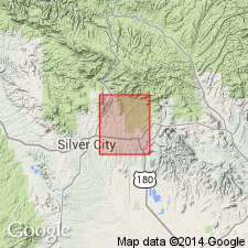
Age modified from Miocene? to Oligocene. Extrusive volcanic activity in the Mogollon-Datil volcanic province, of which the Sugarlump was a part, resumed in the Oligocene. A K-Ar age of 33.4 m.y. was obtained from the overlying Kneeling Nun Tuff. Mapped in the southeast part of quad (adjoins Santa Rita quad) in Basin-and-Range province.
Source: GNU records (USGS DDS-6; Denver GNULEX).
- Usage in publication:
-
- Sugarlump Formation
- Modifications:
-
- Paleomagnetics
- AAPG geologic province:
-
- Basin-and-Range province
Summary:
In the Dwyer quad, southeast of Silver City, Grant Co, NM, Basin-and-Range province, Kneeling Nun Tuff is everywhere reversely magnetized. Underlying Kneeling Nun are the tuff beds of Sugarlump Formation, which interfinger with Rubio Peak andesite and latite [Rubio Peak Formation]. Upper part of the sequence is reversed and the lower part is normal. Magnetostratigraphic position of Kneeling Nun, Sugarlump, and Rubio Peak units within a preliminary model of the middle Tertiary paleomagnetic reversal pattern is depicted on fig. 4. The same correlations can be made in the Lake Valley quad (Jicha, 1954) a few mi to the east.
Source: GNU records (USGS DDS-6; Denver GNULEX).
For more information, please contact Nancy Stamm, Geologic Names Committee Secretary.
Asterisk (*) indicates published by U.S. Geological Survey authors.
"No current usage" (†) implies that a name has been abandoned or has fallen into disuse. Former usage and, if known, replacement name given in parentheses ( ).
Slash (/) indicates name conflicts with nomenclatural guidelines (CSN, 1933; ACSN, 1961, 1970; NACSN, 1983, 2005, 2021). May be explained within brackets ([ ]).