

- Usage in publication:
-
- Straight Canyon formation*
- Modifications:
-
- Named
- Dominant lithology:
-
- Limestone
- Dolomite
- AAPG geologic province:
-
- Great Basin province
Summary:
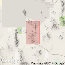
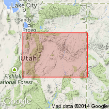
Named for outcrops near Straight Canyon, east-central side Dugway Range, Tooele Co, UT in the Great Basin province. Extends south into Juab Co. Type section measured 1 mi south of Straight Canyon, T10S, R11W, where it overlies Lamb dolomite and underlies Fera limestone (new). Exposed in discontinuous band 1 to 2 mi west of south end of Fandangle Canyon and on several knolls 1 mi southeast of Dugway Pass. Ranges between 360 to 370 ft thick along east side Dugway Range. Is chiefly a medium-grained, gray to dark gray, thin- to medium-bedded and some tan-weathering gray dolomite. Locally mottled light and dark in streaks parallel to bedding in lower part. Lower two-thirds is medium-grained, gray thin- to medium-bedded limestone with some sandy and some nodular patches. Upper one-third is massive gray medium-grained, tan-weathering dolomite and black to gray, fine-grained, thin- to thick-bedded limestone. Has been partially to totally dolomitized. Fossils (trilobites, gastropods) found where unaltered. Equivalent in part to Hamburg dolomite, Mendha and St. Charles limestones. Of early Late Cambrian age. Geologic map. Stratigraphic section.
Source: GNU records (USGS DDS-6; Denver GNULEX).
- Usage in publication:
-
- Straight Canyon Formation*
- Modifications:
-
- Overview
- AAPG geologic province:
-
- Great Basin province
Summary:
Known in Dugway Range, Tooele Co, UT in Great Basin province. Correlation with newly named members of Orr Formation of House Range and Wah Wah Mountains of Millard and Beaver Cos, UT and with other formations in the Great Basin province shown on fig. 2. Is of Late Cambrian age.
Source: GNU records (USGS DDS-6; Denver GNULEX).
For more information, please contact Nancy Stamm, Geologic Names Committee Secretary.
Asterisk (*) indicates published by U.S. Geological Survey authors.
"No current usage" (†) implies that a name has been abandoned or has fallen into disuse. Former usage and, if known, replacement name given in parentheses ( ).
Slash (/) indicates name conflicts with nomenclatural guidelines (CSN, 1933; ACSN, 1961, 1970; NACSN, 1983, 2005, 2021). May be explained within brackets ([ ]).