The National Geologic Map Database is migrating to a new infrastructure. We apologize for any service disruptions during this process.
|
|---|


- Usage in publication:
-
- Stoufferstown member*
- Modifications:
-
- Named
- Dominant lithology:
-
- Limestone
- AAPG geologic province:
-
- Appalachian basin
Summary:
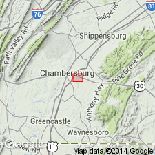
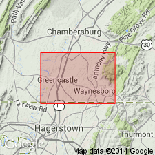
The upper 217 to 224 feet of thin-bedded limestone formerly assigned to the Conococheague limestone in MD, PA, and WV is added as the lowest member of the Stonehenge limestone as the Stoufferstown member. Named for the community of Stoufferstown, Franklin Co., PA. Type section (geologic section 3 in this report) is on Hoover farm, just north of U.S. Highway 30, 2 miles southeast of center of Chambersburg. This member is considered distinctive and mappable and extends from southern PA, through the Great Valley of MD and the eastern panhandle of WV. The Stoufferstown resistant nature produces a persistent ridge. Consists of thin-bedded coarse-grained limestone. Thickness is approximately 300 feet in the Great Valley of PA, MD, and WV. Overlies Conococheague limestone; underlies upper member of Stonehenge limestone. Originally, the contact for the base of the Stonehenge was placed below the pure, fine-grained, massive limestone and above the sandy, conglomeratic, thin-bedded limestone. The distinctiveness of this unit and its diagnostic trilobite assemblage warrants member status and is classified in the Stonehenge because the formational contact with the Conococheague is now closer to the Cambrian-Ordovician boundary. The Stoufferstown member is of Early Ordovician age.
Source: GNU records (USGS DDS-6; Reston GNULEX).
- Usage in publication:
-
- Stoufferstown member
- Modifications:
-
- Overview
- AAPG geologic province:
-
- Appalachian basin
Summary:
Stoufferstown member typically forms a ridge and is approximately 200 feet thick.
Source: GNU records (USGS DDS-6; Reston GNULEX).
- Usage in publication:
-
- Stoufferstown Formation
- Modifications:
-
- Revised
- AAPG geologic province:
-
- Appalachian basin
Summary:
Raised the Stoufferstown member of the Stonehenge to formation status. As the town of Chambersburg has expanded, it has overtaken the community of Stoufferstown and the type section is better located as 12,000 feet east of the center of Chambersburg on U.S. Highway 30. Formation forms a continuous narrow ridge. Consists of coarse-grained mechanical limestone with dark-gray siliceous seams, 200 feet thick. Has a sharp contact with the underlying Shadygrove Formation; gradational contact with the overlying Stonehenge Formation.
Source: GNU records (USGS DDS-6; Reston GNULEX).
- Usage in publication:
-
- Stoufferstown member
- Modifications:
-
- Areal extent
- AAPG geologic province:
-
- Appalachian basin
Summary:
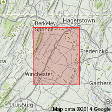
Geographically extended to Virginia. Discusses the Stoufferstown member under the Chepultepec Formation which is the correlative unit to the Stonehenge.
Source: GNU records (USGS DDS-6; Reston GNULEX).
- Usage in publication:
-
- Staufferstown Formation*
- Modifications:
-
- Overview
- AAPG geologic province:
-
- Appalachian basin
Summary:
Stoufferstown Formation is misspelled, Staufferstown, in this publication. The Stoufferstown Formation only shows up on the correlation chart (sheet 1).
Source: GNU records (USGS DDS-6; Reston GNULEX).
For more information, please contact Nancy Stamm, Geologic Names Committee Secretary.
Asterisk (*) indicates published by U.S. Geological Survey authors.
"No current usage" (†) implies that a name has been abandoned or has fallen into disuse. Former usage and, if known, replacement name given in parentheses ( ).
Slash (/) indicates name conflicts with nomenclatural guidelines (CSN, 1933; ACSN, 1961, 1970; NACSN, 1983, 2005, 2021). May be explained within brackets ([ ]).