

- Usage in publication:
-
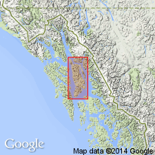
- Stephens Passage Group*
- Modifications:
-
- Named
- Dominant lithology:
-
- Slate
- Graywacke
- Conglomerate
- Volcanics
- AAPG geologic province:
-
- Alaska Southeastern region
Summary:
Named for sequence of slate, graywacke, conglomerate, and augite-bearing volcanic flow breccia, which forms northwest-trending rocks exposed along eastern slopes and shores of Admiralty Island and bordered on east by Douglas Island and Stephens Passage which is designated as type locality. Comprises Seymour Canal Formation, Douglas Island Volcanics (redefined), and Brothers Volcanics (here mapped with Douglas Island Volcanics). Thickness unknown but may exceed 10,000 ft. Underlies with angular unconformity Kootznahoo Formation (new); disconformably overlies Hyd Formation. Is Late Jurassic and Early Cretaceous age based on fossils of Kimmeridgian to Portlandian and Berriasian age collected in lower part of Seymour Canal Formation.
Source: GNU records (USGS DDS-6; Menlo GNULEX).
For more information, please contact Nancy Stamm, Geologic Names Committee Secretary.
Asterisk (*) indicates published by U.S. Geological Survey authors.
"No current usage" (†) implies that a name has been abandoned or has fallen into disuse. Former usage and, if known, replacement name given in parentheses ( ).
Slash (/) indicates name conflicts with nomenclatural guidelines (CSN, 1933; ACSN, 1961, 1970; NACSN, 1983, 2005, 2021). May be explained within brackets ([ ]).