The National Geologic Map Database is migrating to a new infrastructure. We apologize for any service disruptions during this process.
|
|---|


- Usage in publication:
-
- Stafford limestone
- Modifications:
-
- Named
- Dominant lithology:
-
- Limestone
- AAPG geologic province:
-
- Appalachian basin
Summary:
At 823 feet depth in Livonia salt shaft, at Livonia, Livingston Co., NY, occurs 2 feet of compact grayish or chocolate-colored limestone, somewhat bituminous, shaly at top, which is given the name Stafford limestone from its excellent development at Stafford, Genesee Co., NY. Hamilton fossils are very abundant. This unit persists from Livonia eastward probably not less than 50 miles. In the shaft section, as at all its observed outcrops, it bears a Hamilton fauna with a few Marcellus species. The Stafford overlies 28 feet of compact black, very bituminous but not heavy-bedded shales.
Source: GNU records (USGS DDS-6; Reston GNULEX).

- Usage in publication:
-
- Stafford Limestone Member*
- Modifications:
-
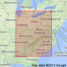
- Areal extent
- AAPG geologic province:
-
- Appalachian basin
Summary:
Stafford Limestone Member of Skaneateles Shale extended from southwestern NY into western PA and into the subsurface in eastern OH, northern WV, and far western MD (Garrett Co.). Marks the base of the Skaneateles and clearly separates it from the underlying Marcellus.
Source: GNU records (USGS DDS-6; Reston GNULEX).
For more information, please contact Nancy Stamm, Geologic Names Committee Secretary.
Asterisk (*) indicates published by U.S. Geological Survey authors.
"No current usage" (†) implies that a name has been abandoned or has fallen into disuse. Former usage and, if known, replacement name given in parentheses ( ).
Slash (/) indicates name conflicts with nomenclatural guidelines (CSN, 1933; ACSN, 1961, 1970; NACSN, 1983, 2005, 2021). May be explained within brackets ([ ]).