

- Usage in publication:
-
- Split Rock Formation*
- Modifications:
-
- Named
- Dominant lithology:
-
- Sandstone
- Conglomerate
- AAPG geologic province:
-
- Green River basin
- Wind River basin
Summary:
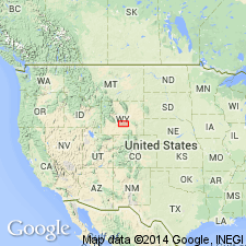
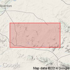
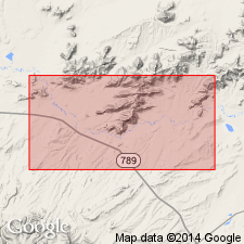
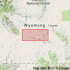
Named for Split Rock (sec 18, T29N, R89W), Natrona Co, WY in the Wind River basin. Crops out over 1500 sq mi. Recognized as far east as Albany Co, WY in the Greater Green River basin. Replaces use of names like Browns Park Formation in this area. Divided into l) lower porous sandstone (500 ft sequence of gray, hard, arkosic conglomerate intertonguing with and overlain by gray, soft porous sandstone; has vertebrate and mollusk fossils), 2) clayey sandstone (100-300 ft sequence of gray, very soft, rounded, quartz grains embedded in white clayey matrix; some siltstone and claystone; no fossils), 3) silty sandstone (0-600 ft sequence of gray to tan, fine- to coarse-grained, rounded grains, soft, porous with silty matrix; vertebrate fossils), 4) upper porous sandstone (0-1000+ ft sequence of white to tan, fine- to coarse-grained, rounded frosted grains, soft, porous; includes conglomerate containing chalcedony pebbles; several algal reefs, pumicite, and limestone beds; has diatom, pollen, and vertebrate fossils). Thickest section is in subsurface in Sinclair Arkansas Creek No. 1 where it is 2732 ft; may exceed 3000 ft elsewhere. Partial section measured in secs 25 and 36, T28N, R89W. Unconformably overlies White River Formation; unconformably underlies Moonstone Formation (new) at type. Is of Miocene age. Has fossil diatoms and vertebrates.
Source: GNU records (USGS DDS-6; Denver GNULEX).
- Usage in publication:
-
- Split Rock Formation*
- Modifications:
-
- Overview
- Areal extent
- AAPG geologic province:
-
- Wind River basin
Summary:
Name extended to Beaver Rim area in Wind River basin and applied to rocks formerly assigned to "Pliocene deposits" and to "lower part of White River formation." Overlies White River Formation. Is a persistent cliff former 150 ft thick along rim to 300 ft thick in subsurface in southwest part of report area. Characterized by massive well-sorted volcanic sandstone and persistent coarse (angular pebbles and cobbles of Precambrian rocks) conglomerate. Fossil gastropods and Hemingfordian mammals identified. Correlates with part of Browns Park? Formation of WY and CO, Colter Formation of northwest WY, and Hemingford Group of NE. Assigned to Miocene.
Source: GNU records (USGS DDS-6; Denver GNULEX).
- Usage in publication:
-
- Split Rock Formation†
- Modifications:
-
- Abandoned
- AAPG geologic province:
-
- Wind River basin
Summary:
Most of the rocks assigned to Split Rock Formation in the Granite Mountains area, Fremont and Natrona Cos, WY in the Wind River basin are equivalent to the Miocene Arikaree Formation of NE. The units that underlie and overlie Arikaree in NE--White River (Oligocene) and Ogallala (Miocene and Pliocene) Formations, respectively can also be recognized in the Granite Mountains. Name Split Rock Formation which encompassed the upper part of White River, all of Arikaree, and the lower part of Ogallala is hereby abandoned.
Source: GNU records (USGS DDS-6; Denver GNULEX).
- Usage in publication:
-
- Split Rock Formation*
- Modifications:
-
- Overview
- AAPG geologic province:
-
- Wind River basin
Summary:
This report was prepared for publication before the paper abandoning Split Rock Formation (Denson, 1965) was written. [Split Rock was replaced by Denson in central WY with the terms (ascending order): upper part of White River Formation, Arikaree Formation, and Ogallala Formation. Use of Split Rock in this professional paper is not a reinstatement of the term into central WY; the Denson nomenclature for the area from the Alcova Dam west along north side of Seminoe, Ferris, and Green Mountains to the southern terminus of the Wind River Range still stands.]
Source: GNU records (USGS DDS-6; Denver GNULEX).
For more information, please contact Nancy Stamm, Geologic Names Committee Secretary.
Asterisk (*) indicates published by U.S. Geological Survey authors.
"No current usage" (†) implies that a name has been abandoned or has fallen into disuse. Former usage and, if known, replacement name given in parentheses ( ).
Slash (/) indicates name conflicts with nomenclatural guidelines (CSN, 1933; ACSN, 1961, 1970; NACSN, 1983, 2005, 2021). May be explained within brackets ([ ]).