

- Usage in publication:
-
- Southward Bridge formation
- Modifications:
-
- Named
- Dominant lithology:
-
- Limestone
- Shale
- Sandstone
- AAPG geologic province:
-
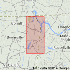
- Black Warrior basin
Morse, W.C., 1928, Paleozoic rocks of Mississippi: Journal of Geology, v. 36, no. 1, p. 31-43.
Summary:
Southward Bridge formation named in northeastern MS. Consists of following intervals (descending): fossiliferous limestone; thick shale and sandstone; fossiliferous limestone; and thick shale. Total thickness 80 ft. Underlies Forest Grove formation and overlies Southward Spring sandstone. Exposed in bluffs of Bear Creek southeast of Southward Spring. Age is Mississippian.
Source: GNU records (USGS DDS-6; Reston GNULEX).
- Usage in publication:
-
- Southward Bridge formation
- Modifications:
-
- Overview
- AAPG geologic province:
-
- Black Warrior basin
Summary:
Formation described. Upper limestone, 5.5 ft thick; lower limestone, 2 to 4 ft thick. Interval between the limestones, 45 to 50 ft thick; and basal shale or clay, approximately 31 ft. Type locality designated at Southward Bridge, near old village of Mingo, where formation is 82 ft 7 in. thick.
Source: GNU records (USGS DDS-6; Reston GNULEX).
- Usage in publication:
-
- Southward Bridge†
- Modifications:
-
- Abandoned
- AAPG geologic province:
-
- Black Warrior basin
Summary:
Name abandoned. Strata included in Sandfall member and Mynot sandstone member of Pride Mountain formation (new).
Source: GNU records (USGS DDS-6; Reston GNULEX).
For more information, please contact Nancy Stamm, Geologic Names Committee Secretary.
Asterisk (*) indicates published by U.S. Geological Survey authors.
"No current usage" (†) implies that a name has been abandoned or has fallen into disuse. Former usage and, if known, replacement name given in parentheses ( ).
Slash (/) indicates name conflicts with nomenclatural guidelines (CSN, 1933; ACSN, 1961, 1970; NACSN, 1983, 2005, 2021). May be explained within brackets ([ ]).