The National Geologic Map Database is migrating to a new infrastructure. We apologize for any service disruptions during this process.
|
|---|


- Usage in publication:
-
- South Canyon Creek dolomite member*
- Modifications:
-
- Original reference
- Dominant lithology:
-
- Dolomite
- AAPG geologic province:
-
- Piceance basin
Summary:
Pg. 1540-1551. South Canyon Creek dolomite member of Maroon formation. On east slope of canyon of South Canyon Creek consists of (1) basal unit of medium-gray, very fine-grained, tough dolomite and dolomitic limestone, 2 feet; (2) middle unit of light-gray, light buff- to light gray-weathering, dense dolomite, 2+ feet; and (3) top unit of gray, thinly laminated, finely crystalline, fossiliferous limestone, 1 foot. In outcrop area, ranges 1.5 to 6+ feet. Dolomite is 480 feet stratigraphically below base of Entrada sandstone on South Canyon Creek and 380 feet below base of Entrada on Main Elk Creek. Brill, 1944 (GSA Bull., v. 55, no. 5) assigned limestone here called South Canyon Creek dolomite member to Triassic Dinwoody or Moenkopi formation. Fossils (pelecypods, gastropods). Fauna appears to be Permian, of Phosphoria age.
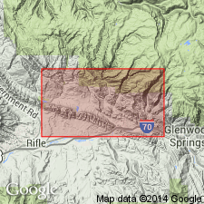
[Named from] exposures in South Canyon Creek, 4.5 mi west of Glenwood Springs, in sec. 2, T. 6 S., R. 90 W., Garfield Co., CO. Exposures continue for about 20+ mi northwestward.
Source: Publication; US geologic names lexicon (USGS Bull. 1200, p. 3667-3668).
- Usage in publication:
-
- South Canyon dolomite member
- Modifications:
-
- Revised
- AAPG geologic province:
-
- Eagle basin
Summary:
Designation incorrectly shown as South Canyon dolomite member [rather than South Canyon Creek dolomite member, the name given by Bass, Northrop, 1950]. Maroon formation limited to beds beneath the Schoolhouse tongue (revised) of the Weber sandstone. The South Canyon occurs about 100 ft above the Schoolhouse in rocks assigned to State Bridge formation in the McCoy area, Eagle Co, CO in the Eagle basin. Lies about 100 ft below "Shinarump conglomerate." Has a molluscan fauna that resembles Phosphoria formation. Correlated with a fossiliferous limy bed at type section of State Bridge. Assigned a Guadalupian, Permian age.
Source: GNU records (USGS DDS-6; Denver GNULEX).
- Usage in publication:
-
- South Canyon Creek Member*
- Modifications:
-
- Overview
- AAPG geologic province:
-
- Piceance basin
Summary:
Has been correlated as a member of the Maroon Formation east from Rio Blanco and Garfield Cos, CO, Piceance basin, with a carbonate unit in the lower part of the State Bridge Formation of the Eagle basin. Farther east in Grand Co, CO, the South Canyon Creek probably passes into siltstone; the carbonate unit does not extend across the ancestral Front Range. Fossils found in South Canyon Creek are long-ranging and not valuable for accurate correlation.
Source: GNU records (USGS DDS-6; Denver GNULEX).
- Usage in publication:
-
- South Canyon Creek Dolomite Member*
- Modifications:
-
- Overview
- AAPG geologic province:
-
- Uinta uplift
- Uinta basin
- Green River basin
Summary:
Franson Member of Park City Formation of northeast UT, Uinta uplift and Uinta basin, and of adjoining northwest CO, Greater Green River basin, shown on a correlation chart as correlative of: 1) the Alibates Dolomite Lentil of the Quartermaster Formation of northeast NM; 2) the South Canyon Creek Dolomite Member of the State Bridge Formation of central CO; 3) the Forelle Limestone of north-central CO and south-central WY; 4) the Day Creek Dolomite of eastern CO and western KS.
Source: GNU records (USGS DDS-6; Denver GNULEX).
For more information, please contact Nancy Stamm, Geologic Names Committee Secretary.
Asterisk (*) indicates published by U.S. Geological Survey authors.
"No current usage" (†) implies that a name has been abandoned or has fallen into disuse. Former usage and, if known, replacement name given in parentheses ( ).
Slash (/) indicates name conflicts with nomenclatural guidelines (CSN, 1933; ACSN, 1961, 1970; NACSN, 1983, 2005, 2021). May be explained within brackets ([ ]).