

- Usage in publication:
-
- Smoky Hollow Member*
- Modifications:
-
- Named
- Dominant lithology:
-
- Coal
- Mudstone
- Sandstone
- AAPG geologic province:
-
- Plateau sedimentary province
Summary:
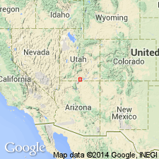
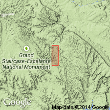
Named as second member (of four) from base of Straight Cliffs Formation for exposures on east side of southeast-trending spur on west side Smoky Hollow, Kane Co, UT. Type section measured in NE1/4 NE1/4 SW1/4 sec 5, T42N, R4E. Occurs in Plateau sedimentary province. Is well exposed in southwestern and central parts of region. Consists of (ascending): basal coal zone, 0-47 ft thick, pale-brown to black carbonaceous mudstone and coal beds (0-4 ft thick); middle barren zone, 13-110 ft thick, dusky-yellow to light-olive-gray bentonitic mudstone interbedded with pale-yellowish-brown and grayish-orange, very fine-grained to medium-grained, horizontally stratified and cross-stratified sandstone that has scattered quartz and chert granules and chert pebbles locally; and Calico bed at top, 0-51 ft thick, white to very light gray, fine- to coarse-grained, poorly sorted, cross-stratified sandstone with locally occurring scattered chert and quartz granules. Overlies Tibbet Canyon Member; unconformably underlies John Henry Member. Deposited in variety of nonmarine environments (paludal, lagoonal (basal coal); fluvial and floodplain (barren zone); fluvial (Calico bed). Contains no diagnostic fossils. Thought to be middle to perhaps late Turonian age, Late Cretaceous.
Source: GNU records (USGS DDS-6; Denver GNULEX).
- Usage in publication:
-
- Smoky Hollow Member*
- Modifications:
-
- Age modified
- AAPG geologic province:
-
- Plateau sedimentary province
Summary:
Cites unpublished Ph.D. thesis (Shanley, 1991, Colo. Sch. Mines, Golden) that assigns an early Coniacian age for upper part of member. Age assignment based on inoceramids. Study area is Kaiparowits Plateau [Plateau sedimentary province], Kane Co, UT. Smoky Hollow is second from base of four members of Straight Cliffs Formation. Overlies Tibbet Canyon and underlies John Henry Members of Straight Cliffs.
Source: GNU records (USGS DDS-6; Denver GNULEX).
For more information, please contact Nancy Stamm, Geologic Names Committee Secretary.
Asterisk (*) indicates published by U.S. Geological Survey authors.
"No current usage" (†) implies that a name has been abandoned or has fallen into disuse. Former usage and, if known, replacement name given in parentheses ( ).
Slash (/) indicates name conflicts with nomenclatural guidelines (CSN, 1933; ACSN, 1961, 1970; NACSN, 1983, 2005, 2021). May be explained within brackets ([ ]).