The National Geologic Map Database is migrating to a new infrastructure. We apologize for any service disruptions during this process.
|
|---|


- Usage in publication:
-
- Shongaloo member
- Modifications:
-
- Named
- Dominant lithology:
-
- Shale
- Sandstone
- Limestone
- Conglomerate
- AAPG geologic province:
-
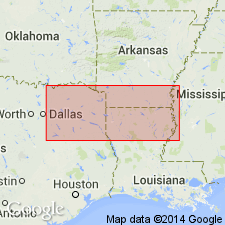
- Arkla basin
- East Texas basin
Summary:
Named for the town and oil field of Shongaloo as basal member of Schuler formation (new) of Cotton Valley group (rank raised). Type section designated in Magnolia Petroleum Co. Sexton Unit No. 1, SW NW SE sec 32, T23N, R9W, Webster Parish, LA where it is identified between 8,400 and 9,450 ft. Well cuttings described. At type, overlies Bossier formation (new), basal formation of Cotton Valley and underlies Dorcheat member (new), upper member of Schuler formation. Is present in subsurface of southern AR and northern LA (Arkla basin), and northeastern TX (East Texas basin). To north, rests unconformably on Buckner or Smackover formation, and is overlapped by Dorcheat. Eastward extent beyond the Mississippi River uncertain. Ranges from 0 in southern AR to more than 1,000 ft thick in LA. In east TX ranges from 600 to 900 ft. Has a nearshore facies of red and green shales and white and red, quartz, angular to subangular sandstones and basal conglomerate of quartz and gray and white chert, and a basinward or offshore facies of dark-gray fossiliferous shales, gray, shelly, sandy, argillaceous, thin-bedded limestone, gray to white, partly calcareous, oyster-bearing, coarse- to fine-grained, partly conglomeratic, thin- to thick-bedded sandstone, and conglomerate layers of well-rounded quartz and gray chert pebbles in a matrix of sandstone or shale. Cross sections. Late Jurassic age. Nomenclature chart.
Source: GNU records (USGS DDS-6; Denver GNULEX).
For more information, please contact Nancy Stamm, Geologic Names Committee Secretary.
Asterisk (*) indicates published by U.S. Geological Survey authors.
"No current usage" (†) implies that a name has been abandoned or has fallen into disuse. Former usage and, if known, replacement name given in parentheses ( ).
Slash (/) indicates name conflicts with nomenclatural guidelines (CSN, 1933; ACSN, 1961, 1970; NACSN, 1983, 2005, 2021). May be explained within brackets ([ ]).