The National Geologic Map Database is migrating to a new infrastructure. We apologize for any service disruptions during this process.
|
|---|


- Usage in publication:
-
- Sherwin glacial stage
- Modifications:
-
- Original reference
- Dominant lithology:
-
- Till
- AAPG geologic province:
-
- Great Basin province
Summary:
Pg. 865-922; 1930 [abs.], GSA Bull., v. 41, p. 91-92. Sherwin stage. Glacial till on east slope of Sierra Nevada of a stage younger than McGee stage and older than Tahoe stage. Correlated with Kansan stage. Age is Pleistocene.
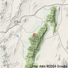
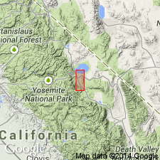
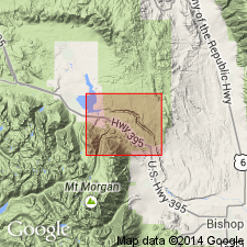
Best developed in area north of Sherwin Hill, northwest of Bishop, in Mount Morrison quadrangle, Sierra Nevada, CA.
Source: US geologic names lexicon (USGS Bull. 896, p. 1985).
- Usage in publication:
-
- Sherwin glacial stage
- Sherwin till
- Modifications:
-
- Principal reference
- Dominant lithology:
-
- Till
- AAPG geologic province:
-
- Great Basin province
Summary:
Pg. 1281, 1290. Sherwin glacial stage; Sherwin till. At least four ice advances occurred in Pleistocene; earliest, here named Aeolian Buttes, was followed by Sherwin, Tahoe, and Tioga previously named by Blackwelder. Constructional forms have been destroyed on the two older tills but preserved on the later ones. Rhyolitic ash and pumice, now Bishop welded tuff, were erupted in interval between Aeolian Buttes and Sherwin glacial stages. Age is Pleistocene.
Type locality (of till): Sherwin Hill, Mount Goddard 15-min quadrangle [1912 ed.], Sierra Nevada, east-central CA [approx. Lat. 37 deg. 30 min. 35 sec. N., Long. 118 deg. 36 min. 40 sec. W., Casa Diablo Mountain 7.5-min quadrangle, Inyo National Forest, Mono Co.]. Greatest expanse of till is in lobe east of Whiskey Canyon; along both sides of Rock Creek gorge, thickness of about 450 feet of glacial detritus is exposed.
Source: US geologic names lexicon (USGS Bull. 1200, p. 3576).
- Usage in publication:
-
- Sherwin glacial stage
- Sherwin till
- Modifications:
-
- Age modified
- AAPG geologic province:
-
- Great Basin province
Summary:
Pg. 233-235, map 1. Sherwin glacial stage; Sherwin till. Sherwin till is pre- rather than post-Bishop tuff. Name Aeolian Buttes considered invalid as representing an earlier Pleistocene, pre-Sherwin glacial stage. Sherwin is second in sequence of four major glacial tills on eastern slope of Sierra Nevada; it was preceded by McGee stage. Part of till rests unconformably on pre-Tertiary crstalline rocks, another part on late Tertiary(?) basalt.
[GNC remark (ca. 1966, US geologic names lexicon, USGS Bull. 1200, p. 3809): Name amended to Sherwin Glaciation in compliance with 1961 Code of Stratigraphic Nomenclature. Adopted by the USGS.]
Source: US geologic names lexicon (USGS Bull. 1200, p. 3576).
For more information, please contact Nancy Stamm, Geologic Names Committee Secretary.
Asterisk (*) indicates published by U.S. Geological Survey authors.
"No current usage" (†) implies that a name has been abandoned or has fallen into disuse. Former usage and, if known, replacement name given in parentheses ( ).
Slash (/) indicates name conflicts with nomenclatural guidelines (CSN, 1933; ACSN, 1961, 1970; NACSN, 1983, 2005, 2021). May be explained within brackets ([ ]).