The National Geologic Map Database is migrating to a new infrastructure. We apologize for any service disruptions during this process.
|
|---|


- Usage in publication:
-
- Shelleburg Canyon formation
- Modifications:
-
- First used
- Dominant lithology:
-
- Sandstone
- Shale
- AAPG geologic province:
-
- Pedregosa basin
- Basin-and-Range province
Summary:
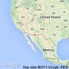
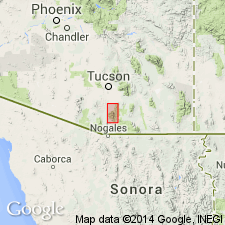
First published use. Recognized in Whetstone Mountains of Cochise, Pima, and Santa Cruz Cos, AZ and in the Empire Mountains of Pima Co, AZ. All the counties, except for Cochise which is in the Pedregosa basin, are in Basin-and-Range province. Overlies Apache Canyon formation (first published use) and underlies Turney Ranch formation (first published use). Is composed of quartzose and arkosic, gray, red, and yellow sandstone, and thin-bedded to laminated, gray-olive, red shale. A section 2,650 feet thick measured [but not described in paper] in Pump and Sanford Canyons. Dinosaur bones, several biostromes containing fragments of pelecypods, casts of ostracods, and silicified wood found. Total thickness in Cienega Wash is approximately 3,600 feet. Of Cretaceous age.
Source: GNU records (USGS DDS-6; Denver GNULEX).
- Usage in publication:
-
- Shellenberger Canyon Formation*
- Modifications:
-
- Revised
- AAPG geologic province:
-
- Pedregosa basin
- Basin-and-Range province
Summary:
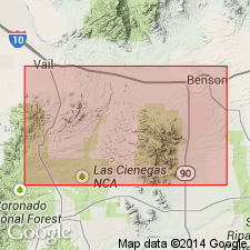
Is a formation of the Bisbee Group in Empire Mountains, Basin-and-Range province and Whetstone Mountains, Pedregosa basin. Type section in Whetstone Mountains extends from NE1/4 NE1/4 sec 34, T18S, R18E to SW1/4 NE1/4 sec 4, T19S, R18E, Pima Co, AZ. Consists of an alternating sequence of shale, siltstone, sandstone, and a little limestone. The shale and siltstone are shades of brown and gray, and some beds contain carbonized plant fragments and silicified logs. Sandstone is brown, green, and gray, fine to very coarse grained, arkosic, massive to cross-bedded and lenticular. Some sandstones are conglomeratic and contain pebbles of quartzite and chert as much as 1 inch in diameter. Limestone is mainly restricted to lower 1,300 ft of formation. Conformably overlies Apache Canyon Formation (adopted) and conformably overlain by Turney Ranch Formation (adopted). Generally ranges in thickness from 3,950 to 4,330 ft, but to north, lower 1,000 ft grades laterally into Glance Conglomerate. Name changed from Shelleburg Canyon to Shellenberger Canyon to conform with accepted spelling on USGS topographic map. Is of Early Cretaceous age; fossil clams.
Source: GNU records (USGS DDS-6; Denver GNULEX).

- Usage in publication:
-
- Shellenberger Canyon Formation*
- Modifications:
-
- Overview
- AAPG geologic province:
-
- Basin-and-Range province
- Pedregosa basin
Summary:
Is formation of Bisbee Group in Santa Rita Mountains (Santa Cruz and Pima Cos, AZ) and Empire Mountains (Pima Co, AZ) in Basin-and-Range province, and in Whetstone Mountains (Pima and Cochise Cos, AZ) in Basin-and-Range province and Pedregosa basin. Overlies Apache Canyon Formation (Aptian and Albian) with gradational contact; underlies Turney Ranch Formation (Albian) with conformable contact. Upper part of Shellenberger Canyon and its contact with presumably overlying Turney Ranch not exposed in Santa Rita Mountains. Generally ranges in thickness from 3,950 to 4,330 ft, except near north end of Empire Mountains where basal 1,000 ft grades laterally into Glance Conglomerate. Less than 1,000 ft of basal part is represented in Santa Rita Mountains. Is considered roughly equivalent to Cintura Formation in Mule and Huachuca Mountains. Age is shown to be Albian (Early Cretaceous) on correlation chart (fig. 5).
Source: GNU records (USGS DDS-6; Denver GNULEX).
- Usage in publication:
-
- Shellenberger Canyon Formation*
- Modifications:
-
- Areal extent
- AAPG geologic province:
-
- Basin-and-Range province
Summary:
Extended to Santa Rita Mountains of Basin-and-Range province. Is of Early Cretaceous age.
Source: GNU records (USGS DDS-6; Denver GNULEX).
For more information, please contact Nancy Stamm, Geologic Names Committee Secretary.
Asterisk (*) indicates published by U.S. Geological Survey authors.
"No current usage" (†) implies that a name has been abandoned or has fallen into disuse. Former usage and, if known, replacement name given in parentheses ( ).
Slash (/) indicates name conflicts with nomenclatural guidelines (CSN, 1933; ACSN, 1961, 1970; NACSN, 1983, 2005, 2021). May be explained within brackets ([ ]).