

- Usage in publication:
-
- Seymour Canal Formation*
- Modifications:
-
- Named
- Dominant lithology:
-
- Argillite
- Graywacke
- Conglomerate
- AAPG geologic province:
-
- Alaska Southeastern region
Summary:
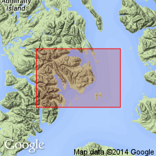
Named for thick sequence of argillite, graywacke, and conglomerate exposed at type locality at mouth of Seymour Canal in northeast Pybus-Gambier area, Admiralty Island, southeastern AK. Unit forms eastern and southeastern border of area. Crops out in broad belt which bends sinuously through Pybus Bay from Elliott Island northeastward to Point Pybus, and thence beneath waters of Stephens Passage. Reappears in eastern Gambier Bay where unit forms nearly rectilinear belt of outcrops trending north-northwest and extending almost continuously along shores of Seymour Canal for distance of about 40 mi north of Gambier Bay. Thickness ranges from 4000 to 8000 ft. Disconformably overlies Hyd Formation (new); conformably underlies Brothers Volcanics (new). Shown on geologic map of Pybus-Gambier area. Fossil collections indicate age ranges from Late Jurassic to Early Cretaceous.
Source: GNU records (USGS DDS-6; Menlo GNULEX).
- Usage in publication:
-
- Seymour Canal Formation*
- Modifications:
-
- Revised
- Areal extent
- AAPG geologic province:
-
- Alaska Southeastern region
Summary:
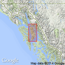
Unit now included in Stephens Passage Group (new). Shown on geologic map of Admiralty Island, AK extending unit to Symonds Point at northern tip. Rocks formerly mapped as Symonds Formation (Barker, 1957) are here mapped as Seymour Canal Formation, and name "Symonds Formation" is abandoned. Seymour Canal Formation disconformably overlies Triassic rocks. Conformably underlies Douglas Island Volcanics of Stephens Passage Group.
Source: GNU records (USGS DDS-6; Menlo GNULEX).
- Usage in publication:
-
- Seymour Canal Formation*
- Modifications:
-
- Areal extent
- AAPG geologic province:
-
- Alaska Southeastern region
Summary:
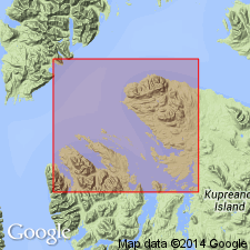
Shown on geologic map of Keku Islets and neighboring parts of Kuiu and Kupreanof Island, southeastern AK. Crops out on north shore of Kupreanof Island for about 30 mi. No fossils found but lithologic correlation with Seymour Canal Formation of Admiralty Island indicates age remains Late Jurassic and Early Cretaceous.
Source: GNU records (USGS DDS-6; Menlo GNULEX).
For more information, please contact Nancy Stamm, Geologic Names Committee Secretary.
Asterisk (*) indicates published by U.S. Geological Survey authors.
"No current usage" (†) implies that a name has been abandoned or has fallen into disuse. Former usage and, if known, replacement name given in parentheses ( ).
Slash (/) indicates name conflicts with nomenclatural guidelines (CSN, 1933; ACSN, 1961, 1970; NACSN, 1983, 2005, 2021). May be explained within brackets ([ ]).