

- Usage in publication:
-
- Sevier shale*
- Modifications:
-
- Original reference
- Dominant lithology:
-
- Shale
- Limestone
- AAPG geologic province:
-
- Appalachian basin
Summary:
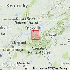
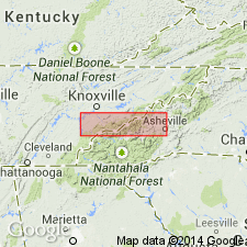
Pg. 4. Sevier shale. Shales overlying Tellico sandstone and underlying Bays sandstone in Knoxville quadrangle, eastern Tennessee. As a whole is a thick series of calcareous yellow shales, weathered from light-blue shaly limestone. Is similar to the Athens shale. With it occur occasional beds of gray limestone or variegated marble and beds of sandy shale and calcareous sandstone. Southeast of Knoxville it consists of 200 to 300 feet of gray argillaceous limestone, gray and variegated marble, and shaly limestone overlain by 1,000 to 1,200 feet of calcareous yellow shales with occasional thin limestone beds and sandy shales. North of Montvale Springs there are two heavy beds of sandy shale and calcareous sandstone interbedded with light-blue shaly limestone. The shales are precisely like Athens shale and the sandstones very similar to Tellico sandstone. Passing northeast the sandstones diminish in thickness and are more interbedded with shales. Fossils similar to those of Chickamauga limestone are common in the limestones and marbles of this formation.
Source: US geologic names lexicon (USGS Bull. 896, p. 1960-1961).
- Usage in publication:
-
- Sevier shale
- Modifications:
-
- Revised
- AAPG geologic province:
-
- Appalachian basin
Summary:
Sevier shale. Near Friendsville, central Tennessee, includes Meadow marble member (new). [Age is Middle Ordovician.]
Source: US geologic names lexicon (USGS Bull. 1200, p. 3533-3534).

- Usage in publication:
-
- Sevier shale*
- Modifications:
-
- Overview
- AAPG geologic province:
-
- Appalachian basin
Summary:
Sevier shale of Blount group. Foregoing [see Keith, USGS Knoxville folio, no. 16, 1895 entry] is original definition in type area. The name however, first appeared in print in 1894, in a paper on southwestern Virginia by M.R. Campbell (GSA Bull., v. 5, pl. 4), who accepted Keith's name and correlated the rocks of southwestern Virginia with those of Knoxville quadrangle, eastern Tennessee. As described by Campbell, the formation in southwestern Virginia underlies Bays sandstone and overlies Shenandoah limestone. The name was also used by Campbell in USGS Estillville folio (no. 12), published in 1894, where the formation is described as 440 to 4,000 feet thick; consisting of yellow or blue calcareous shale, becoming quite sandy in upper part to southeast; basal part north of Clinch River consisting of few feet to 800 feet of black shale; underlies Bays sandstone and overlies Chickamauga limestone north of Clinch River and Moccasin limestone south of Clinch River.
The Ottosee shale of Ulrich is basal calcareous member of typical Sevier shale. In early reports and folios of southwestern Virginia the younger Martinsburg shale was erroneously mapped as Sevier shale.
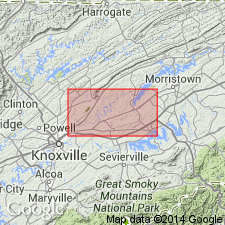
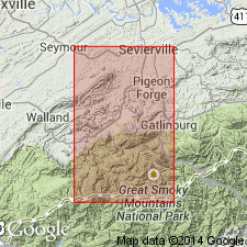
Named from exposures in Sevier Co., eastern TN. Extends into western NC, and southwestern VA. Age is Early Ordovician (Chazy).
Source: US geologic names lexicon (USGS Bull. 896, p. 1960-1961).

- Usage in publication:
-
- Sevier shale
- Modifications:
-
- Revised
- AAPG geologic province:
-
- Appalachian basin
Summary:
Pg. 1182-1183. Sevier shale. Discussion of lower Middle Ordovician of southwestern Virginia and northeastern Tennessee and suggests recommendations for revision of nomenclature. The Sevier and "Ottosee" are essentially equivalent formations, the latter being named by Ulrich to obviate use of term Sevier, which had been erroneously applied to the younger Martinsburg formation in much of earlier mapping in Virginia and Tennessee. In this respect, Ottosee formation offers no improvement over Sevier since it too has been applied erroneously in northeast Tennessee and southwest Virginia. Gratton limestone is absent in Knoxville region. Benbolt and Wardell equivalents are not readily differentiated lithologically. Therefore, terms Benbolt and Wardell are not applicable in that area; either Sevier should be redefined or a new formational name applied to these beds. According to type description, the Sevier occurs between Tellico and "Bays" sandstones. The type Bays is same as the Moccasin. The latter is in better usage in Tennessee and Virginia and should have precedence over "Bays." Base of Moccasin as generally mapped was not included in type Moccasin by Campbell and was assigned name Bowen (Cooper and Prouty, 1943). The Bowen forms base of the "Bays" and would therefore mark top of Sevier formation. The Sevier might be redefined as bluish-gray huffish-weathering shaly limestone occurring between the Tellico sandstone and Bowen formation. In absence of the latter, the Sevier would underlie Witten limestone and, in absence of this, would underlie Moccasin proper. Section southeast of Lenoir City, Tennesse, may serve as a standard for the Sevier. Inasmuch as the Sevier contains equivalents of the Benbolt, Gratton(?), and Wardell, it might be considered a group. However, it is useful as a mapping unit in Tennessee and is herein maintained under formational status.
Source: US geologic names lexicon (USGS Bull. 1200, p. 3533-3534).
- Usage in publication:
-
- Sevier shale
- Modifications:
-
- Areal extent
- AAPG geologic province:
-
- Appalachian basin
Summary:
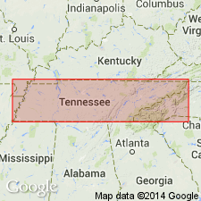
Geographically extended the Sevier shale of the Blount group to GA.
Consists of about 100 feet of yellowish, fossiliferous shale. Unit overlies the Holston marble and is of Middle Ordovician age.
Source: GNU records (USGS DDS-6; Reston GNULEX).
- Usage in publication:
-
- Sevier shale*
- Modifications:
-
- Revised
- AAPG geologic province:
-
- Appalachian basin
Summary:
Named the Bacon Bend member of the Sevier shale for the distinctive interval in the top 40 to 165 feet of the formation. The Bacon Bend member consists of calcareous shales characterized by slump-bedding structures. The Sevier shale consists of calcareous shale, calcareous sandstone, and calcarenite that is about 1800 feet thick. Unit overlies the Chota formation and underlies the Bays formation. The Sevier is of Middle Ordovician age.
Source: GNU records (USGS DDS-6; Reston GNULEX).
- Usage in publication:
-
- Sevier shale*
- Modifications:
-
- Revised
- AAPG geologic province:
-
- Appalachian basin
Summary:
Discarded the term Blount group, therefore removing the Sevier shale from that group.
Source: GNU records (USGS DDS-6; Reston GNULEX).
- Usage in publication:
-
- Sevier formation*
- Modifications:
-
- Revised
- AAPG geologic province:
-
- Appalachian basin
Summary:
Revised the Sevier to the Sevier formation in TN. Consists of 200 to 400 feet of gray, calcareous sandy shale. Unit overlies the Chota formation and underlies the Bays formation. The Sevier is of Middle Ordovician age.
Source: GNU records (USGS DDS-6; Reston GNULEX).
For more information, please contact Nancy Stamm, Geologic Names Committee Secretary.
Asterisk (*) indicates published by U.S. Geological Survey authors.
"No current usage" (†) implies that a name has been abandoned or has fallen into disuse. Former usage and, if known, replacement name given in parentheses ( ).
Slash (/) indicates name conflicts with nomenclatural guidelines (CSN, 1933; ACSN, 1961, 1970; NACSN, 1983, 2005, 2021). May be explained within brackets ([ ]).