The National Geologic Map Database is migrating to a new infrastructure. We apologize for any service disruptions during this process.
|
|---|


- Usage in publication:
-
- Selmier Member
- Modifications:
-
- Named
- Dominant lithology:
-
- Shale
- Dolomite
- Sandstone
- AAPG geologic province:
-
- Cincinnati arch
Summary:
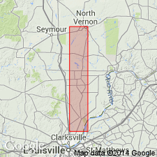
Selmier Member of New Albany Shale formally proposed in central IN in this report. Unit is brownish-black and olive-brown fissile shale with thin beds of dolomite and dolomitic sandstone. Thickness 22 ft at type section in North Vernon, Jennings Co. Overlies Blocher Member (revised); underlies Morgan Trail Member (new). Selmier Member is continuous with Sweetland Creek Shale of New Albany Group of IL. Corresponds to lower part of lower member of Blackiston Formation of Campbell (1946), abandoned in IN. Equivalent rocks are included in the Antrim Shale of the Michigan basin. Stratigraphy is more fully described by Lineback (1970: IN Geol. Survey Bull. 44).
Source: GNU records (USGS DDS-6; Reston GNULEX).

- Usage in publication:
-
- Selmier Member
- Modifications:
-
- Overview
- Areal extent
- AAPG geologic province:
-
- Cincinnati arch
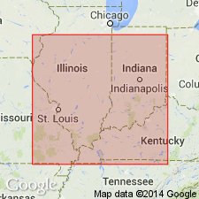
- Illinois basin
Summary:
Selmier Member of the New Albany Shale is composed primarily of gray shale, but contains thin beds of brownish-black shale, dolomite, limestone, and quartzose sandstone. Fossils include conodonts, pelecypods, and gastropods. Subsurface Selmier was redefined by Hasenmueller and Bassett (1981) to include some of the dark-gray shales that Lineback (1970) had included in the upper part of the underlying Blocher Member. At the base of the Selmier are light-gray quartz sandstone beds and laminae. The Selmier is absent from most of Harrison, Floyd, and Clark Cos. Member is 6 ft thick near Scottsburg in Scott Co. and thickens northward to more than 40 ft in southwestern Bartholomew Co. It thickens to the southwest and in Posey Co. attains its maximum known thickness of 126 ft. Member corresponds to the SPATHIOCARIS Zone of Campbell (1946). Correlates with the Sweetland Creek Shale of the New Albany Group mapped by North (1969) in southeastern IL, the Sweetland Creek Member of the New Albany Shale mapped by Schwalb and Norris (1980) in northwestern KY and the lower part of the Sweetland Creek Shale mapped by North (1969) in the northeastern part of the Illinois basin in IL. Mostly equivalent to the Selmier Shale mapped by Cluff and others (1981) in southeastern IL. It is not recognized in the Michigan basin, but it is stratigraphically equivalent to part of the Antrim Shale of northern IN and MI. May be equivalent to the upper part of the Olentangy of OH, which Tillman (1970) determined is Late Devonian in age. Also equivalent to the upper part of the Dowelltown Member of the Chattanooga Shale of TN.
Source: GNU records (USGS DDS-6; Reston GNULEX).
- Usage in publication:
-
- Selmier Member, Shale
- Modifications:
-
- Overview
- AAPG geologic province:
-
- Illinois basin
Summary:
Selmier Member of New Albany Shale has been traced from the outcrop area in southeastern IN into the subsurface of southwestern IN. The name has been extended to KY as a member of the New Albany and into IL where it is used at formation rank. In IL, this interval had been assigned to the Sweetland Creek Shale by Collinson and others (1967), but it was determined by Reinbold and others (1980) that the Sweetland Creek occupies a higher stratigraphic position than the Selmier and so is restricted to areas north and west of the deeper parts of the basin. The two units are separated by an arbitrary vertical cutoff. The Selmier consists of greenish- to olive-gray shale and thin beds of olive-black shale, dolomite, and quartzose sandstone. In the subsurface, unit generally contains more organic carbon than in outcrop. Unit appears to be absent in southeastern IN, but thickens to more than 40 ft in central IN. Reaches 126 ft in Posey Co. and 200 ft in southeastern IL and western KY. Thins to 20 ft in central IL, where it adjoins the Sweetland Creek Shale. Conodonts indicate a Late Devonian age.
Source: GNU records (USGS DDS-6; Reston GNULEX).

- Usage in publication:
-
- Selmier Member*
- Modifications:
-
- Biostratigraphic dating
- AAPG geologic province:
-
- Illinois basin
- Cincinnati arch
Summary:
Conodont biostratigraphy of the Selmier Member of the New Albany Shale indicates that it is of Late Devonian (Frasnian) age. Conodonts of the RHENANA and LINGUIFORMIS Zones were recovered. Unit overlies the Blocher Member and underlies the Morgan Trail Member, both of the New Albany Shale.
Source: GNU records (USGS DDS-6; Reston GNULEX).
For more information, please contact Nancy Stamm, Geologic Names Committee Secretary.
Asterisk (*) indicates published by U.S. Geological Survey authors.
"No current usage" (†) implies that a name has been abandoned or has fallen into disuse. Former usage and, if known, replacement name given in parentheses ( ).
Slash (/) indicates name conflicts with nomenclatural guidelines (CSN, 1933; ACSN, 1961, 1970; NACSN, 1983, 2005, 2021). May be explained within brackets ([ ]).