

- Usage in publication:
-
- Saginaw Bay Formation*
- Modifications:
-
- Named
- Dominant lithology:
-
- Volcaniclastics
- Chert
- Limestone
- AAPG geologic province:
-
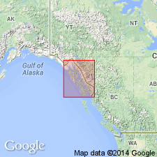
- Alaska Southeastern region
Summary:
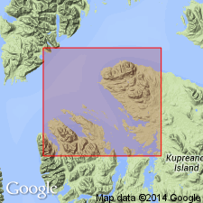
Type locality designated as long islet near head of Saginaw Bay and adjacent shore of bay to south, northern Kuiu Island, southeastern AK. Crops out in north part of Kuiu Island and Keku Islets. Supplementary section designated on southeast side of cove 3.4 mi southeast of triangulation station "Corn" at tip of Cornwallis Peninsula. Consists of heterogeneous sequence of sedimentary and volcanic rocks. Divided into (oldest to youngest): volcanic member, black chert member, chert and limestone member, and silty limestone member. Thickness of volcanic and black chert members not definitely known. Chert and limestone member is at least 400 ft thick, silty limestone member about 300 ft thick. Apparently conformably underlies Halleck Formation (new). Inferred to overlie crinoid limestone of Mississippian(?) age. Shown on geologic map of Keku Islets and neighboring parts of Kuiu and Kupreanof Islands. Tentatively assigned Mississippian and Pennsylvanian age based in part on fossils identified by J.T. Dutro, Jr. (oral commun., 1963).
Source: GNU records (USGS DDS-6; Menlo GNULEX).
- Usage in publication:
-
- Saginaw Bay Formation*
- Modifications:
-
- Age modified
- AAPG geologic province:
-
- Alaska Southeastern region
Summary:
Devonian conodonts were found in unit. Age is therefore Devonian to Pennsylvanian.
Source: GNU records (USGS DDS-6; Menlo GNULEX).
For more information, please contact Nancy Stamm, Geologic Names Committee Secretary.
Asterisk (*) indicates published by U.S. Geological Survey authors.
"No current usage" (†) implies that a name has been abandoned or has fallen into disuse. Former usage and, if known, replacement name given in parentheses ( ).
Slash (/) indicates name conflicts with nomenclatural guidelines (CSN, 1933; ACSN, 1961, 1970; NACSN, 1983, 2005, 2021). May be explained within brackets ([ ]).