The National Geologic Map Database is migrating to a new infrastructure. We apologize for any service disruptions during this process.
|
|---|


- Usage in publication:
-
- Rutledge limestone*
- Modifications:
-
- Original reference
- Dominant lithology:
-
- Limestone
- Shale
- AAPG geologic province:
-
- Appalachian basin
Summary:
Pg. 2. Rutledge limestone. As a whole the strata are limestone, but there are many beds of green and yellow calcareous shale toward base, which form a passage into underlying Rome formation. The limestones are massive and range in color from blue to dark blue, black, and gray. Thickness 250 to 500 feet. Underlies Rogersville shale. [Age is Middle Cambrian.]
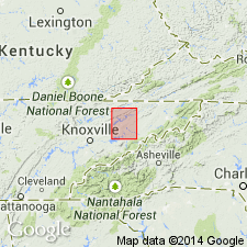
[Named from exposures in valley of Rutledge, Grainger Co., northeastern TN.]
Source: US geologic names lexicon (USGS Bull. 896, p. 1859).

- Usage in publication:
-
- Rutledge limestone*
- Modifications:
-
- Overview
- AAPG geologic province:
-
- Appalachian basin
Summary:
Foregoing [see Keith 1896 USGS Morristown folio (no. 27) entry] is original definition at type locality. The name, however, first appeared in print in 1894, in USGS Estillville folio (no. 12), by M.R. Campbell, who accepted Keith's name, correlating the rocks of Estillville quadrangle with those of Morristown quadrangle. He described the formation as consisting of 200 to 240 feet of very dark impure magnesium limestone at top, its base being quite siliceous and containing many thin beds of sandy shale, and as overlying Russell formation and underlying Rogersville shale. Keith also published the name in 1895, in USGS Knoxville folio (no. 16), in which area the formation is described as 350 to 450 feet thick, with same lithology as in Morristown quadrangle, and as overlying Rome formation and underlying Rutledge limestone.
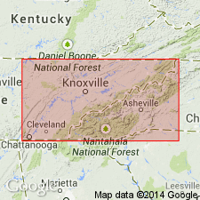
Named from exposures in valley of Rutledge, Grainger Co., northeastern TN. Extends into southwestern VA, and western NC. Age is Middle Cambrian.
Source: US geologic names lexicon (USGS Bull. 896, p. 1859).
- Usage in publication:
-
- Rutledge limestone
- Modifications:
-
- Revised
- AAPG geologic province:
-
- Appalachian basin
Summary:
The Rutledge limestone is revised to be included in the Conasauga group in eastern TN and southwestern VA. Unit is the second formation in the group. Thickness is 100 to 500 feet. Overlies the Pumpkin Valley shale and underlies the Rogersville shale.
Source: GNU records (USGS DDS-6; Reston GNULEX).
- Usage in publication:
-
- Rutledge Limestone*
- Modifications:
-
- Revised
- Areal extent
- AAPG geologic province:
-
- Appalachian basin
Summary:
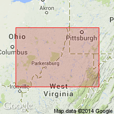
In cross section E-E', in the Rome trough area, subsurface of west-central West Virginia, Rutledge Limestone extended into West Virginia and is used for micritic limestone and sandstone. Correlates with argillaceous sandy limestone previously assigned to the lower part of the Maryville Limestone by Webb (1980), to the sandy Rome unit of the Rome Formation by Sutton (1981), and to the limestone in the lower part of the Maryville by Donaldson and others (1988). Intertongues westward with sandstone of the Rome Formation; grades eastward into the Elbrook Dolomite. Shown as part of the Conasauga Group. Age is Middle Cambrian.
Source: GNU records (USGS DDS-6; Reston GNULEX).
For more information, please contact Nancy Stamm, Geologic Names Committee Secretary.
Asterisk (*) indicates published by U.S. Geological Survey authors.
"No current usage" (†) implies that a name has been abandoned or has fallen into disuse. Former usage and, if known, replacement name given in parentheses ( ).
Slash (/) indicates name conflicts with nomenclatural guidelines (CSN, 1933; ACSN, 1961, 1970; NACSN, 1983, 2005, 2021). May be explained within brackets ([ ]).