The National Geologic Map Database is migrating to a new infrastructure. We apologize for any service disruptions during this process.
|
|---|


- Usage in publication:
-
- Rusty Zone
- Modifications:
-
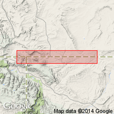
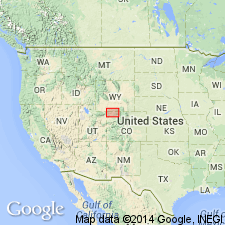
- Areal extent
- AAPG geologic province:
-
- Green River basin
Summary:
Retained as name for middle member of Ericson formation in Rock Springs uplift and Vermillion basin areas of Greater Green River basin. Consists mainly of shale. Overlies Trail Member of Ericson. Underlies Canyon Creek Member of Ericson. Thickens to south and southeast from north part of Rock Springs uplift. Near Black Butte Mountain (T17N, R101W) is about 400 ft thick and consists of gray shale with occasional thin streak of coal. To south in Vermillion basin area is 300 to 400 ft thick and consists of gray shale. Where exposed in sec 7, T10N, R100W, Moffat Co, CO it is 320 ft thick and contains massive sandstones and a few thin, carbonaceous to coaly shales; a few thin sandstones weather a rusty-brown color. In Middle Mountain area is much thinner and consists of medium- to coarse-grained sandstones with some coaly shales. Is about 160 ft thick at Clay basin and composed of brown-weathering sandstones and some thin shales. Is 210 ft thick on south end of Rock Springs uplift and includes rusty-weathering sandstones and gray shales. Is 65 ft thick on west flank of uplift in Aspen Mountain area. Thins northward (as Ericson thins) along west flank of Rock Springs uplift; near Winton, WY it cannot be recognized with any certainty. Age is Late Cretaceous.
Source: GNU records (USGS DDS-6; Denver GNULEX).
- Usage in publication:
-
- Rusty zone*
- Modifications:
-
- Areal extent
- AAPG geologic province:
-
- Green River basin
Summary:
Is [middle member] of Ericson Sandstone in Washakie basin, Sweetwater Co, WY and northwest part of Sand Wash basin, Moffat Co, CO (both basins part of Greater Green River basin). Delta-plain deposits correlated from outcrop near Rock Springs, WY southeast into subsurface of Washakie and Sand Wash basins on basis of electric-log correlations. Areally extended in subsurface as far as gas well (station 5, sec 33, T12N, R97W) in Moffat Co, CO. Overlies Trail Member (Smith, 1961) of Ericson. Unconformably underlies Canyon Creek Member (Smith, 1961) of Ericson. Is shown to be correlative with delta-plain deposits in middle part of Iles Formation of Mesaverde Group. Late Cretaceous age.
Source: GNU records (USGS DDS-6; Denver GNULEX).
For more information, please contact Nancy Stamm, Geologic Names Committee Secretary.
Asterisk (*) indicates published by U.S. Geological Survey authors.
"No current usage" (†) implies that a name has been abandoned or has fallen into disuse. Former usage and, if known, replacement name given in parentheses ( ).
Slash (/) indicates name conflicts with nomenclatural guidelines (CSN, 1933; ACSN, 1961, 1970; NACSN, 1983, 2005, 2021). May be explained within brackets ([ ]).