The National Geologic Map Database is migrating to a new infrastructure. We apologize for any service disruptions during this process.
|
|---|


- Usage in publication:
-
- Roan gneiss*
- Modifications:
-
- Named
- Dominant lithology:
-
- Gneiss
- AAPG geologic province:
-
- Appalachian basin
Summary:
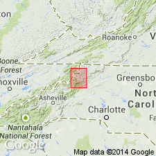
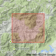
Named for Roan Mountain, Carter Co., northeastern TN. Mapped in a small area of TN in Johnson Co. and in NC south of Cranberry and northeast of Boone. Consists of hornblende gneiss, hornblende schist, and diorite with some interbedded mica schist and gneiss. Chiefly hornblende schist. Hornblendic beds are dark greenish or black; micaceous beds are dark gray. Mica schist and gneiss beds range in thickness from a few inches to 100 ft and are frequent only near Carolina gneiss into which they form transition. Appears to cut Carolina gneiss, but contacts are so metamorphosed that it cannot be proved. Age is Archean.
Source: GNU records (USGS DDS-6; Reston GNULEX).
- Usage in publication:
-
- Roan gneiss*
- Modifications:
-
- Areal extent
- AAPG geologic province:
-
- Piedmont-Blue Ridge province
Summary:
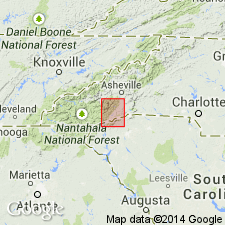
Roan gneiss extended to SC in Pickens Co. Age is Archean.
Source: GNU records (USGS DDS-6; Reston GNULEX).
- Usage in publication:
-
- Roan gneiss*
- Modifications:
-
- Overview
- AAPG geologic province:
-
- Appalachian basin
Summary:
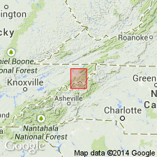
Roan gneiss mapped in its type area of Roan Mountain on both sides of TN-NC boundary. Age is Archean.
Source: GNU records (USGS DDS-6; Reston GNULEX).
- Usage in publication:
-
- Roan gneiss
- Modifications:
-
- Not used
- AAPG geologic province:
-
- Piedmont-Blue Ridge province
Summary:
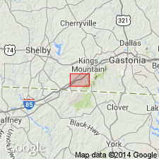
Pg. 756, 775-781. Roan gneiss. Near Kings Mountain, mica schists and gneisses, previously mapped as Carolina gneiss, and hornblende gneisses, previously mapped as Roan gneiss, actually constitute metamorphosed upper part of Gaffney [formation]. Similar rocks in Beaver Creek area are apparently stratigraphically higher. Evidence in other parts of Carolina Piedmont, indicates that intrusive diorite and possibly recrystallized mafic volcanic rocks have been included in the Roan and possibly recrystallized felsic volcanic rocks in the Carolina gneiss. Names Roan and Carolina have lithologic but not stratigraphic significance.
Source: US geologic names lexicon (USGS Bull. 1200, p. 3293).
- Usage in publication:
-
- Roan gneiss†
- Modifications:
-
- Abandoned
- AAPG geologic province:
-
- Piedmont-Blue Ridge province
Summary:
The names Roan gneiss and Carolina gneiss have been used widely in southeastern US by Keith and later geologists. Type localities for each are vaguely defined. Stratigraphic equivalence of all rocks mapped as Cranberry and Roan is questionable. Exclusively intrusive origin for Roan is questionable. Author prefers not to apply formation names to metamorphic rocks in report area. Using old names, or renaming rocks would perpetuate or cause confusion; therefore, Roan gneiss and Carolina gneiss are herein abandoned.
Source: GNU records (USGS DDS-6; Reston GNULEX).
- Usage in publication:
-
- Roan gneiss†
- Modifications:
-
- Abandoned
- AAPG geologic province:
-
- Piedmont-Blue Ridge province
Summary:
Roan gneiss abandoned in area of report. Considered a lithologic variant of Carolina gneiss.
Source: GNU records (USGS DDS-6; Reston GNULEX).

- Usage in publication:
-
- Roan Gneiss
- Modifications:
-
- Mapped
- AAPG geologic province:
-
- Appalachian basin
- Piedmont-Blue Ridge province
Summary:
Precambrian Roan Gneiss mapped in Johnson, Carter, and Unicoi Cos. [thereby extending Roan into Appalachian basin]. Consists of layered hornblende and garnet gneiss and granitic migmatite with zones of mica schist and amphibolite. Foliation is commonly contorted. Contains numerous granitic and gabbroic dikes.
Source: GNU records (USGS DDS-6; Reston GNULEX).
- Usage in publication:
-
- Roan Gneiss
- Modifications:
-
- Not used
- AAPG geologic province:
-
- Piedmont-Blue Ridge province
Summary:
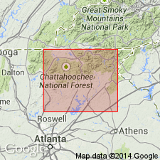
Rocks previously mapped as part of Roan Gneiss by Keith (1909) are here named Chestatee Member of Canton Formation of New Georgia Group.
Source: GNU records (USGS DDS-6; Reston GNULEX).
For more information, please contact Nancy Stamm, Geologic Names Committee Secretary.
Asterisk (*) indicates published by U.S. Geological Survey authors.
"No current usage" (†) implies that a name has been abandoned or has fallen into disuse. Former usage and, if known, replacement name given in parentheses ( ).
Slash (/) indicates name conflicts with nomenclatural guidelines (CSN, 1933; ACSN, 1961, 1970; NACSN, 1983, 2005, 2021). May be explained within brackets ([ ]).