- Usage in publication:
-
- River Portal mica schist*
- Modifications:
-
- Named
- Dominant lithology:
-
- Schist
- AAPG geologic province:
-
- Southern Rocky Mountain region
Summary:
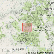
Named for exposures in vicinity of river portal of Gunnison tunnel, T49N, R7W, Montrose Co, CO in Southern Rocky Mountain region. No type locality specifically designated. Consists of somber-gray, brown weathering quartz-mica schists found on Vernal Mesa and along adjacent portion of Black Canyon from a point a little more than l mi east of mouth of Cimarron Creek to beginning of Vernal Mesa granite mass, in vicinity of Big Draw and Grizzle Gulch. The exposed strip runs in northwesterly direction for 13 mi. Full extent of River Portal schist not known. In contact with Black Canyon schist to east and with Vernal Mesa granite to west. Assigned to pre-Cambrian.
Source: GNU records (USGS DDS-6; Denver GNULEX).

- Usage in publication:
-
- River Portal Mica Schist†
- Modifications:
-
- Abandoned
- AAPG geologic province:
-
- Southern Rocky Mountain region
Summary:
Abandoned herein. Impractically distinguished from Black Canyon Schist. Not recognized in recent mapping. Was a unit of Gunnison River area listed with pre-1,700 m.y. (Precambrian X) metamorphic complex.
Source: GNU records (USGS DDS-6; Denver GNULEX).
For more information, please contact Nancy Stamm, Geologic Names Committee Secretary.
Asterisk (*) indicates published by U.S. Geological Survey authors.
"No current usage" (†) implies that a name has been abandoned or has fallen into disuse. Former usage and, if known, replacement name given in parentheses ( ).
Slash (/) indicates name conflicts with nomenclatural guidelines (CSN, 1933; ACSN, 1961, 1970; NACSN, 1983, 2005, 2021). May be explained within brackets ([ ]).

