

- Usage in publication:
-
- Riceville shales
- Modifications:
-
- Named
- Dominant lithology:
-
- Shale
- AAPG geologic province:
-
- Appalachian basin
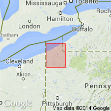
Summary:
Named Riceville shales for exposures on Oil Creek in bluff just west of Riceville, Crawford Co., PA. Unit is very fossiliferous drab or bluish-gray sandy shales, sometimes shaly sandstones; no black or red layers. Riceville is 80 feet thick; underlies Cussewago sandstone and overlies Venango oil sand group. Unit is considered of Late Devonian age.
Source: GNU records (USGS DDS-6; Reston GNULEX).
- Usage in publication:
-
- Riceville Formation
- Modifications:
-
- Areal extent
- AAPG geologic province:
-
- Appalachian basin
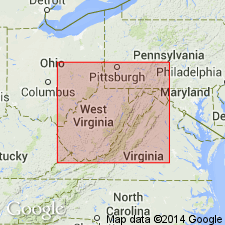
Summary:
Riceville Formation is described in the subsurface of north-central WV where it represents Greenland Gap-like lithologies that transgressed eastward across Venango shorelines in latest Devonian time. Unit forms eastward-thinning siltstone wedges that intertongue with sandstone of the Oswayo Formation. In study area, overlies Venango Formation and underlies Berea Sandstone. Where Berea is absent, unit underlies Cuyahoga Formation.
Source: GNU records (USGS DDS-6; Reston GNULEX).
- Usage in publication:
-
- Riceville Formation
- Modifications:
-
- Overview
- AAPG geologic province:
-
- Appalachian basin
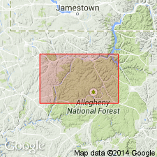
Summary:
Riceville in Warren Co comprises fissile, medium-gray, bluish-gray, dark-brown, and purplish-red shales; thin, scattered medium-gray siltstones; and minor, thin, scattered, very fine grained, light-gray sandstones that are locally calcareous. Unit ranges in thickness from 125 to 170 ft. Grades laterally eastward into the Oswayo Formation near Warren. Exposures are rare. Overlies the Venango Formation; underlies unnamed clastics beneath the Corry Sandstone in western Warren Co. and underlies Knapp Formation toward the east. Depositional environment interpreted as offshore shelf during marine transgression. Age is Late Devonian.
Source: GNU records (USGS DDS-6; Reston GNULEX).
For more information, please contact Nancy Stamm, Geologic Names Committee Secretary.
Asterisk (*) indicates published by U.S. Geological Survey authors.
"No current usage" (†) implies that a name has been abandoned or has fallen into disuse. Former usage and, if known, replacement name given in parentheses ( ).
Slash (/) indicates name conflicts with nomenclatural guidelines (CSN, 1933; ACSN, 1961, 1970; NACSN, 1983, 2005, 2021). May be explained within brackets ([ ]).