The National Geologic Map Database is migrating to a new infrastructure. We apologize for any service disruptions during this process.
|
|---|


- Usage in publication:
-
- Red Warrior limestone*
- Modifications:
-
- Named
- Dominant lithology:
-
- Limestone
- AAPG geologic province:
-
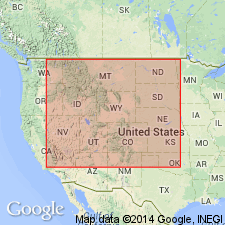
- Great Basin province
Summary:
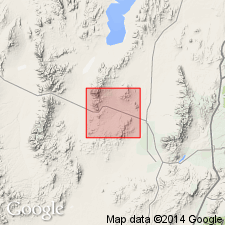
Named for Red Warrior mine, T28S, R11W, Beaver Co, UT in the Great Basin province. No type locality designated. Mapped in south part of area in T28S, R11W, being exposed in a belt one-half to three-fourths of a mile wide. Is underlain by Morehouse? quartzite, a covered contact, of Silurian age. Is conformably overlain by Mowitza shale (new) of Devonian age. Covers about 1 sq mi of the Star district. Approximately 1,500 ft thick. Consists of heavy-bedded blue, dolomitic and in part siliceous, limestone. Lenses of quartzite present in lower part. Few beds of gray limestone in upper part. The limestone has been intruded and altered. An offshore deep water deposit. No fossils found. Silurian? and Devonian? age assignment based on stratigraphic position and on regional correlation with other rocks.
Source: GNU records (USGS DDS-6; Denver GNULEX).
- Usage in publication:
-
- Red Warrior Limestone*†
- Modifications:
-
- Abandoned
Summary:
Red Warrior Limestone abandoned. Its rocks reassigned to the lower part of the Upper Devonian Pinyon Peak Limestone, the Devonian Sevy Dolomite, Simonson Dolomite, and Guilmette Formation, and to the Silurian Laketown Dolomite.
Source: GNU records (USGS DDS-6; Denver GNULEX).
For more information, please contact Nancy Stamm, Geologic Names Committee Secretary.
Asterisk (*) indicates published by U.S. Geological Survey authors.
"No current usage" (†) implies that a name has been abandoned or has fallen into disuse. Former usage and, if known, replacement name given in parentheses ( ).
Slash (/) indicates name conflicts with nomenclatural guidelines (CSN, 1933; ACSN, 1961, 1970; NACSN, 1983, 2005, 2021). May be explained within brackets ([ ]).