The National Geologic Map Database is migrating to a new infrastructure. We apologize for any service disruptions during this process.
|
|---|


- Usage in publication:
-
- Red Plume Quartzite
- Modifications:
-
- Named
- Dominant lithology:
-
- Quartzite
- Sandstone
- AAPG geologic province:
-
- Northern Rocky Mountain region
Summary:
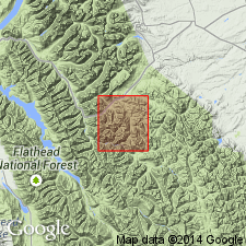
Named as the upper formation of Kintla Group of Belt Supergroup for exposures called the type section from 600 ft down the west slope from summit of Blacktail Mountain to about 630 ft down the east slope, latitude 48 degrees 17 minutes north longitude, 113 degrees 28 minutes 30 seconds west, (type section), Flathead Co, MT in the Northern Rocky Mountain region. Is predominately a medium- to very thick-bedded, medium-grained, rounded to subrounded pink-lavender quartzite and sandstone. Some beds have red argillite flakes and pebbles; most quartzites are pure. Large-scale cross-bedding is prominent. Is 791 ft thick at type where it conformably overlies bright-red and maroon beds of Shields Formation (new name) and underlies green argillite and quartzite, an upper unnamed unit of Belt Supergroup. Assigned a Precambrian age.
Source: GNU records (USGS DDS-6; Denver GNULEX).
For more information, please contact Nancy Stamm, Geologic Names Committee Secretary.
Asterisk (*) indicates published by U.S. Geological Survey authors.
"No current usage" (†) implies that a name has been abandoned or has fallen into disuse. Former usage and, if known, replacement name given in parentheses ( ).
Slash (/) indicates name conflicts with nomenclatural guidelines (CSN, 1933; ACSN, 1961, 1970; NACSN, 1983, 2005, 2021). May be explained within brackets ([ ]).