The National Geologic Map Database is migrating to a new infrastructure. We apologize for any service disruptions during this process.
|
|---|


- Usage in publication:
-
- Red Narrows Conglomerate
- Modifications:
-
- Named
- Reference
- Dominant lithology:
-
- Conglomerate
- Sandstone
- Siltstone
- Limestone
- AAPG geologic province:
-
- Wasatch uplift
Summary:
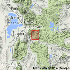
Named for exposures in Red Narrows Canyon, Utah Co, UT, Wasatch uplift. Type section measured from NE1/4, SW1/4, SE1/4, sec 33, T9S, R5E northeasterly to NW1/4, SW1/4, SW1/4 sec 15, T9S, R5E. Reference section measured in sec 30, T9S, R5E (lower member). Measured sections. Geologic map. Columnar and cross sections. Areal extent beyond quad is 30 mi north-south, and 15 mi east-west. Formerly called Red Narrows facies of North Horn, or part of Wasatch or Price River Formations. Lower member is white, brown to red conglomerate of white sandstone and Paleozoic limestone cobbles in a sandstone matrix cemented by silica or calcite, 400 ft thick. Middle member is gray, fine-grained, calcareous, medium- to thick-bedded sandstone interbedded with red siltstone, and conglomerate of cobbles and pebbles of quartzite and Paleozoic limestone in red sand matrix and calcite cement, 690 ft thick. Upper member has 1) red, gray-weathering, very fine crystalline, slightly sandy, thick-bedded limestone, and 2) brown, thick-bedded algal limestones separated by reddish-brown calcareous siltstone, sandstone, and gray conglomerate (quartzite and Paleozoic limestone pebbles to cobbles in a red-brown sandstone matrix), 380 ft thick. Unconformably above Cretaceous conglomerate; intertongues with Price River, North Horn, and Flagstaff Formations. Overlain by Flagstaff. An alluvial-fan(?) deposit with local lacustrine basins unit. Maestrichtian to Paleocene age.
Source: GNU records (USGS DDS-6; Denver GNULEX).
- Usage in publication:
-
- Red Narrows Conglomerate
- Modifications:
-
- Areal extent
- Revised
- AAPG geologic province:
-
- Great Basin province
Summary:
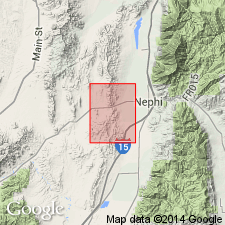
Exposures of red siltstone, sandstone, and conglomerate in southeast part of Nephi NW 7 1/2-min quad, Juab Co, UT in the Great Basin province, assigned by some earlier workers to North Horn Formation are assigned to Red Narrows Conglomerate in this report. Is about 50 percent conglomerate and 50 percent sandstone. Conglomerate is mostly quartzite clasts that range from small pebbles to boulders derived from Cambrian and Precambrian rocks. Paleozoic limestone clasts present too. Forms red, rounded hills and gullies. Probably an alluvial fan deposit. Distinguished from other conglomerates by clast content and color. Unconformably above conglomerate of Spring Canyon. Unconformably below Orme Spring Conglomerate (new). Correlated with upper part of North Horn Formation, Canyon Range Conglomerate, and lower part of Flagstaff Formation. Of Late Cretaceous and Paleocene age. Correlation chart.
Source: GNU records (USGS DDS-6; Denver GNULEX).
For more information, please contact Nancy Stamm, Geologic Names Committee Secretary.
Asterisk (*) indicates published by U.S. Geological Survey authors.
"No current usage" (†) implies that a name has been abandoned or has fallen into disuse. Former usage and, if known, replacement name given in parentheses ( ).
Slash (/) indicates name conflicts with nomenclatural guidelines (CSN, 1933; ACSN, 1961, 1970; NACSN, 1983, 2005, 2021). May be explained within brackets ([ ]).