The National Geologic Map Database is migrating to a new infrastructure. We apologize for any service disruptions during this process.
|
|---|


- Usage in publication:
-
- Raton Hills group*
- Modifications:
-
- Original reference
- Dominant lithology:
-
- Coal
- AAPG geologic province:
-
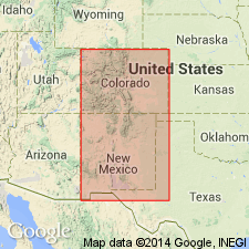
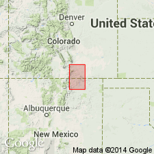
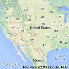
- Las Vegas-Raton basin
Summary:
Pg. 89-91. The next group comprises the coal beds of the Raton Hills, which I suspect is also a portion of the great lignite group, and will eventually be found to be synchronous with it. I have called it Raton Hills group.
Source: US geologic names lexicon (USGS Bull. 896, p. 1775).
- Usage in publication:
-
- Raton formation*
- Modifications:
-
- Revised
- Adopted
- AAPG geologic province:
-
- Las Vegas-Raton basin
Lee, W.T., 1913, Recent discovery of dinosaurs in the Tertiary: American Journal of Science, 4th series, v. 35, no. 209, p. 531-534.
Summary:
Pg. 531. Raton formation is name recently adopted by the USGS for the coal-bearing rocks above the unconformity in Raton Mesa region of southern Colorado and northern New Mexico. The coal-bearing rocks below the unconformity have been named Vermejo formation. The two constitute what has heretofore been called Laramie in this region. The data upon which they were separated are contained in a forthcoming paper by W.T. Lee and F.H. Knowlto, on Raton Mesa region, which will be published by the USGS [see entry under USGS Prof. Paper 101, 1917].
[GNC remark (ca. 1936, US geologic names lexicon, USGS Bull. 896, p. 1775): Hayden's Eocene and Upper Cretaceous †Raton Hills group of Raton Mesa region, southeastern Colorado, abandoned.]
Source: US geologic names lexicon (USGS Bull. 896, p. 1775).
- Usage in publication:
-
- Raton formation*
- Modifications:
-
- Biostratigraphic dating
- AAPG geologic province:
-
- Las Vegas-Raton basin
Summary:
Pg. 241. Plants correlate Raton formation with Denver and Arapahoe formations of Denver basin, and latter is practically continuous with Dawson arkose.
Source: US geologic names lexicon (USGS Bull. 896, p. 1775).
- Usage in publication:
-
- Raton formation*
- Modifications:
-
- Principal reference
- Revised
- Adopted
- AAPG geologic province:
-
- Las Vegas-Raton basin
Summary:
Pg. 40, 56-61. Raton formation. The name Raton was first used by Hayden to indicated all coal-bearing rocks which he observed near Raton Mesa. As used by him it included the beds now assigned to Vermejo formation, but as the Vermejo is not conspicuously exposed along the route traversed by Hayden, and as most of the rocks he called "Raton Hills group" belong to the coal-bearing formation above the Vermejo, the name Raton has been adopted for this formation. The type area of Raton formation is in the high mesa region between Trinidad, Colorado, and Raton, New Mexico, erroneously called mountains, that culminates in Fishers Peak. No complete section of the rocks is exposed in the slopes of this highest mesa, called Raton Mesa, but in the side of Bartlett Mesa, north of town of Raton [New Mexico] from locality 75 (see pl. 1 in pocket) to south point of the mesa, these rocks are well exposed. In Raton Mesa the top of Raton formation is 2,000+/- feet higher than its base, and probably at no other locality in region is so great a thickness of this formation preserved. The rocks of the formation vary in character from coal and carbonaceous shale to sandy shale, sandstone, and conglomerate; in most places they weather yellowish brown. Most of conglomerate occurs at base of formation, but in southwestern part of Raton field conglomerates were found far above the base. The base in nearly all parts of Raton Mesa region is conglomeratic. Coal occurs throughout formation. In western part of region the conglomerate at base contains much arkosic material, is several hundred feet thick, coarse, massive, and resistant, but it thins and becomes finer-grained toward east. The Raton (of Eocene age) rests unconformably on Vermejo formation (of Montana, Late Cretaceous, age) and is overlain by Poison Canyon formation. Near Trinidad there are many places where it is difficult to draw line separating Raton formation from the Vermejo, but in western part of region, south of Spanish Peaks, in southern and eastern parts as far north as Canadian River, and in eastern part of Trinidad coal field north of Trinidad, there is little difficulty in recognizing the conglomeratic sandstone that constitutes base of Raton formation. The Raton has generally been regarded as unconformable with Poison Canyon formation. It seems possible the Poison Canyon and Raton formations may differ but little in age, and that their physical differences may be due to local variations in conditions of sedimentation.
[GNC remark (ca. 1936, US geologic names lexicon, USGS Bull. 896, p. 1775): Hayden's Eocene and Upper Cretaceous †Raton Hills group of Raton Mesa region, southeastern Colorado, abandoned.]
Source: US geologic names lexicon (USGS Bull. 896, p. 1775).
- Usage in publication:
-
- Raton Formation*
- Modifications:
-
- Areal extent
- AAPG geologic province:
-
- Las Vegas-Raton basin
Summary:
Raton Formation, in central and eastern parts of Raton coal field, Colfax Co, NM, Las Vegas-Raton basin, consists of three generally recognizable field divisions: a basal sandstone, conglomeratic throughout western part of field; a lower zone, predominantly sandstone and mudstone; and an upper coal-bearing zone (0-1000 ft thick, thins to west), largely sandstone, siltstone, and mudstone, with beds of coal--several of these coal beds were first used in this report. Coal beds in central part of field are (ascending): lower Left Fork, upper Left Fork, Cottonwood Canyon, Ancho Canyon, York Canyon, and Chimney Divide. Coal beds in eastern part of field are (ascending): Sugarite, "Brown", "Green", Tin Pan, and Potato Canyon. Coal beds in Raton Formation may prove to be the most economically significant in the coal field. Special circumstances of deposition control the accumulation of thick coal deposits; because these conditions are of a regional nature, occurrence of one thick coal at a particular stratigraphic position in one area should provide a clue to position of other similar deposits elsewhere in basin. Raton Formation is overlain by Paleocene Poison Canyon Formation, and overlies Late Cretaceous Vermejo Formation--Vermejo conformably overlies Trinidad Sandstone but is locally absent beneath the base of overlying Raton Formation. Raton is of Late Cretaceous and Paleocene age [coal beds are probably all Paleocene age].
Source: GNU records (USGS DDS-6; Denver GNULEX).
For more information, please contact Nancy Stamm, Geologic Names Committee Secretary.
Asterisk (*) indicates published by U.S. Geological Survey authors.
"No current usage" (†) implies that a name has been abandoned or has fallen into disuse. Former usage and, if known, replacement name given in parentheses ( ).
Slash (/) indicates name conflicts with nomenclatural guidelines (CSN, 1933; ACSN, 1961, 1970; NACSN, 1983, 2005, 2021). May be explained within brackets ([ ]).