

- Usage in publication:
-
- Ranchester Limestone Member*
- Modifications:
-
- Named
- Reference
- Dominant lithology:
-
- Limestone
- Dolomite
- AAPG geologic province:
-
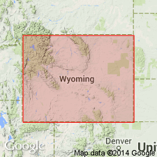
- Powder River basin
- Bighorn basin
Summary:
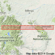
Named as the upper member of Amsden Formation for town of Ranchester, 6 mi northeast of Dayton, Sheridan Co, WY in Powder River and Bighorn basins. Type section located in SE1/4 sec 33, T57N, R87W on Amsden Creek, 4 mi west of Dayton, in Sheridan Co. Reference section designated in lower Tensleep Canyon (sta 190), T47N, R88W, Washakie Co. Consists predominantly of carbonate (limestone, dolomitic limestone, and dolomite) that may be gray, tan, pink, purple, dense, or finely crystalline, massive, and cherty. Crops out as a series of massive ledges. Red, orange-red, white, gray, and tan chert which occurs as nodular masses, fracture fillings, and as banded beds commonly littering Amsden slopes. Locally sandstone predominates in upper part. Carbonate beds separated by white-gray sandstone, siltstone, and claystone. Ranges from 0-250 ft thick. Overlies Horseshoe Shale Member of Amsden and underlies Tensleep Sandstone. Is a fossiliferous marine unit that ranges from Morrow to Atoka, or Early and Middle Pennsylvanian age. Correlates with middle part of Morgan Formation, lower part of Casper and Fountain Formations, and lower middle Hartville and Minnelusa Formations. Columnar sections. Areal extent maps. Correlation diagrams.
Source: GNU records (USGS DDS-6; Denver GNULEX).
- Usage in publication:
-
- Ranchester Limestone Member*
- Modifications:
-
- Overview
- Reference
- Dominant lithology:
-
- Dolomite
- Limestone
- AAPG geologic province:
-
- Powder River basin
- Bighorn basin
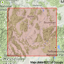
- Wind River basin
- Green River basin
Summary:
Reference section designated at SW1/4 sec 34, T57N, R87W, Sheridan Co, WY, the type section of the Amsden Formation, where Ranchester 1) is 123 ft thick; 2) overlies Horseshoe Shale Member of Amsden; 3) underlies Tensleep Sandstone; 4) consists of interbedded medium-crystalline to fine-grained dolomite and olive-gray, medium-grained limestone. Is the most widespread of all the members of the Amsden, being present in the Powder River, Bighorn, Wind River, and Greater Green River basins, and the Yellowstone province, WY. Averages 100 ft thick, though it may be as much as 250 ft thick. Conformably overlies Horseshoe Shale Member over most of area except for western mountains of WY where it lies conformably on the Moffat Trail Limestone Member (new). Is conformably and transitionally overlain by Tensleep Sandstone throughout its extent. Contains late Chesterian (Late Mississippian) to Atokan (Early and Middle Pennsylvanian) fossils (Foraminifera). Is a restricted, shallow, warm-water, offshore marine deposit. Cross sections.
Source: GNU records (USGS DDS-6; Denver GNULEX).
- Usage in publication:
-
- Ranchester Limestone Member*
- Modifications:
-
- Areal extent
- AAPG geologic province:
-
- Montana folded belt
Summary:
Columnar sections (fig. 3) show Ranchester Limestone Member of Amsden Formation occurs as the only member of Amsden near Sheep Creek section, Blacktail Mountains, Beaverhead Co, MT; Ranchester extends northeast to Arasta Creek section in Gravelly Range, Madison Co, MT; continues northeast to area of Tobacco Root Range where Amsden Formation becomes Amsden Group. Here Ranchester is shown to interfinger with formations of Amsden Group. From Tobacco Root Range northeast to Lombard Station section in Horseshoe Hills, Madison Co, Amsden Group consists of (ascending) Tyler Formation, Alaska Bench Limestone, and Devils Pocket Formation. Study area is within Montana folded belt province. Overlies Conover Ranch Formation (new) of Snowcrest Range Group (new); underlies Quadrant Sandstone. Shown as Mississippian and Pennsylvanian age.
Source: GNU records (USGS DDS-6; Denver GNULEX).
For more information, please contact Nancy Stamm, Geologic Names Committee Secretary.
Asterisk (*) indicates published by U.S. Geological Survey authors.
"No current usage" (†) implies that a name has been abandoned or has fallen into disuse. Former usage and, if known, replacement name given in parentheses ( ).
Slash (/) indicates name conflicts with nomenclatural guidelines (CSN, 1933; ACSN, 1961, 1970; NACSN, 1983, 2005, 2021). May be explained within brackets ([ ]).