The National Geologic Map Database is migrating to a new infrastructure. We apologize for any service disruptions during this process.
|
|---|


- Usage in publication:
-
- Quatal red clay member
- Modifications:
-
- Areal extent
- Dominant lithology:
-
- Shale
- AAPG geologic province:
-
- Santa Maria basin
- Ventura basin
Summary:
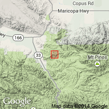
Pg. 35-37, pl. 33 (geol. map). Quatal red clay member of Santa Margarita formation. Nonmarine facies of the Santa Margarita. Consists of brown, clay-like shale that does not form natural outcrops. In places it contains selenite crystals and is cut by satin spar veinlets. Underlies a sandstone bed and overlies a gypsum bed stratigraphically above Caliente red beds. Total thickness of shale and sandstone above the gypsum is 75 to 100 feet. Occurs in Quatal Canyon gypsum deposit, between Ballinger and Quatal Canyons, Ventura County, southern California (pl. 33). Age of Santa Margarita is late Miocene.
Source: Publication; US geologic names lexicon (USGS Bull. 1200, p. 3171-3172); GNU records (USGS DDS-6; Menlo GNULEX).
- Usage in publication:
-
- Quatal formation*
- Modifications:
-
- Principal reference
- Revised
- AAPG geologic province:
-
- Santa Maria basin
- Ventura basin
Summary:
Pg. 2974 (fig. 1), 2978 (fig. 3), 2996, 2997 (fig. 11). Quatal formation is herein designated as the nonmarine claystone and sandstone, probably upper Miocene in age, that lies conformably between Caliente formation below and Morales formation above. At type locality, the formation, of probable lacustrine origin, is approximately 800 feet thick and consists of reddish-gray soft thin-bedded gypsiferous claystones weathering to reddish clay soil; contains basal bed of white massive gypsum that attains maximum thickness of 30 feet in Quatal Canyon. In southern part of Cuyama Badlands, formation thickens to about 2,700 feet and becomes mainly fluviatile pebbly sandstone of prevailing orange-buff color of which only basal 500 feet is lacustrine red claystone. West of mouth of Quatal Canyon, on west bank of Cuyama River, formation consists of about 600 feet of light brown sandstone-cobble conglomerate and sandstone which grades westward along strike into marine Santa Margarita sandstone. On northeast slope of Caliente Range adjoining Carrizo Plain, type Caliente redbeds are overlain conformably by about 700 feet of soft gray gypsiferous lacustrine claystone containing some thin-bedded hard sandstones in basal part; these claystones are believed to be correlative with Quatal red claystone of Cuyama Badlands but could belong to overlying Morales formation. Name replaces preoccupied Apache formation (Dibblee, IN Chester Stock, 1947, South. Calif. Acad. Sci. Bull., v. 46, pt. 2, p. 84-89).
Type locality: in Ballinger Canyon, Cuyama Badlands, Ballinger Canyon 7.5-min quadrangle, Santa Barbara and Ventura Cos., southern CA.
Source: Publication; US geologic names lexicon (USGS Bull. 1200, p. 3171-3172); GNU records (USGS DDS-6; Menlo GNULEX).
- Usage in publication:
-
- Quatal Formation*
- Modifications:
-
- Adopted
- Age modified
- AAPG geologic province:
-
- Santa Maria basin
- Ventura basin
Summary:
Quatal Formation, as redefined by Hill and others (1958), is adopted by the USGS. (Previously Quatal Red Clay Member of Santa Margarita Formation of Ver Planck, 1952.) Is conformably overlain by Morales Formation. Age is Pliocene (Hemphillian NALMA), based on stratigraphic relations to Caliente Formation which conformably underlies the Quatal and contains mammalian remains diagnostic of the Hemphillian, citing Savage [abs.], 1957 (GSA Bull., v. 68, no. 12, pt. 2, p. 1845).
Source: Changes in stratigraphic nomenclature, 1973 (USGS Bull. 1395-A, p. A34-A35); supplemental information from GNU records (USGS DDS-6; Menlo GNULEX).
For more information, please contact Nancy Stamm, Geologic Names Committee Secretary.
Asterisk (*) indicates published by U.S. Geological Survey authors.
"No current usage" (†) implies that a name has been abandoned or has fallen into disuse. Former usage and, if known, replacement name given in parentheses ( ).
Slash (/) indicates name conflicts with nomenclatural guidelines (CSN, 1933; ACSN, 1961, 1970; NACSN, 1983, 2005, 2021). May be explained within brackets ([ ]).