

- Usage in publication:
-
- Puppets Formation
- Modifications:
-
- Named
- Dominant lithology:
-
- Metarhyolite
- Volcanics
- AAPG geologic province:
-
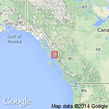
- Alaska Southeastern region
Summary:
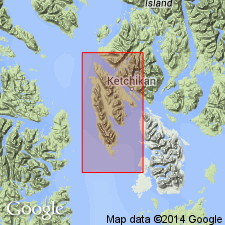
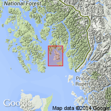
[Named for The Puppets]. Type locality: The Puppets-Punch Hill area, secs.17,19, and 22, T77S R91E and sec.24 T77S R90E, S Gravina Island, southeastern AK. Divided into two intertonguing members: metarhyolite member (massive appearing to thinly layered recrystallized felsic volcanic unit) and metatuff member (recrystallized felsic volcaniclastic unit). Metatuff generally at or near base. Approximate thickness of metarhyolite 150 ft, metatuff 400 ft. Metatuff crops out on southern and western Gravina Island; divided into massive nonfoliated type and slaty to phyllitic foliated type; purple, green, and buff colors. Metarhyolite crops out on southern Gravina Island between Nehenta Bay and Bostwick Inlet; weathers light gray or brownish gray with hummocky and cliff-like outcrops. Unconformably overlies Silurian or older Paleozoic rocks. Unconformably underlies unnamed limestones of middle Paleozoic, probably Devonian, age or Nehenta Formation. No fossils. Age is middle Paleozoic based on stratigraphic position.
Source: GNU records (USGS DDS-6; Menlo GNULEX).
- Usage in publication:
-
- Puppets Formation*
- Modifications:
-
- Age modified
- AAPG geologic province:
-
- Alaska Southeastern region
Summary:
Age of Puppets Formation, unnamed correlatives, and unnamed conformably overlying massive limestone and dolomite unit on Annette and Gravina Islands changed from middle Paleozoic to: Late Triassic on the basis of corals and conodonts (EPIGONDOILELA sp which is restricted to Late Triassic) from conformably overlying limestones on eastern Annette Island. Fossils identified by Anita Harris.
Source: GNU records (USGS DDS-6; Menlo GNULEX).
- Usage in publication:
-
- Puppets Formation
- Modifications:
-
- Revised
- AAPG geologic province:
-
- Alaska Southeastern region
Summary:
Puppets Formation on Gravina Island included in Hyd Group which is geographically extended south to Gravina and Annette Islands. Assignment based on similar rock types, stratigraphic position, and age. On Kuiu Island rhyolitic rocks similar to the Puppets excluded from group and named Keku Volcanics. On Gravina and Annette Islands, rhyolitic Puppets Formation here included in group. [As shown on Fig.9 rhyolitic rocks are interbedded with rocks of Nehenta Formation as are thus included in group.] U-Pb (zircon) apparent age of 225 +/-3 Ma from rhyolite.
Source: GNU records (USGS DDS-6; Menlo GNULEX).
- Usage in publication:
-
- Puppets Formation*
- Modifications:
-
- Revised
- AAPG geologic province:
-
- Alaska Southeastern region
Summary:
Puppets Formation on Gravina Island included in Hyd Group which is geographically extended S to include rocks on Gravina and Annette Islands. Adopted for the USGS [based on Gehrels, Saleeby, and Berg, 1987].
Source: GNU records (USGS DDS-6; Menlo GNULEX).
For more information, please contact Nancy Stamm, Geologic Names Committee Secretary.
Asterisk (*) indicates published by U.S. Geological Survey authors.
"No current usage" (†) implies that a name has been abandoned or has fallen into disuse. Former usage and, if known, replacement name given in parentheses ( ).
Slash (/) indicates name conflicts with nomenclatural guidelines (CSN, 1933; ACSN, 1961, 1970; NACSN, 1983, 2005, 2021). May be explained within brackets ([ ]).