The National Geologic Map Database is migrating to a new infrastructure. We apologize for any service disruptions during this process.
|
|---|


- Usage in publication:
-
- Pocamoonshine Gabbro-Diorite*
- Modifications:
-
- Named
- Dominant lithology:
-
- Gabbro
- Diorite
- AAPG geologic province:
-
- New England province
Summary:
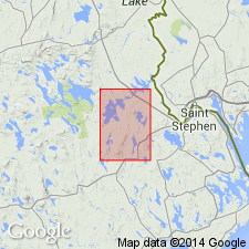
Pocamoonshine Gabbro-Diorite, named in this report, is described as a medium gray-green to black gabbro-diorite. This intrusive mass is about 3 mi wide, 15 mi long, and extends southward into Wesley quad. Age believed to be Devonian. Love Ridge Quartz Monzonite (new) and Wabassus Quartz Monzonite are also mapped as Devonian in the report area.
Source: GNU records (USGS DDS-6; Reston GNULEX).
- Usage in publication:
-
- Pocamoonshine Gabbro-Diorite*
- Modifications:
-
- Areal extent
- AAPG geologic province:
-
- New England province
Summary:
Pocamoonshine Gabbro-Diorite is described in Grand Lake area where it is 6 mi wide in the Wesley quad. Shown on map legend below Chiputneticook Quartz Monzonite and unit termed slate at Baskahegan Stream. Age is Devonian.
Source: GNU records (USGS DDS-6; Reston GNULEX).
- Usage in publication:
-
- Pocamoonshine Gabbro-Diorite*
- Pocomoonshine Gabbro-Diorite
- Modifications:
-
- Overview
GNU Staff, 1991, GNU Staff remark on Pocamoonshine Gabbro-Diorite in Maine.: U.S. Geological Survey Digital Data Series, DDS-6, 1 CD-ROM., release 3
Summary:
Recent authors have spelled name "Pocomoonshine." BGN [Board of Geographic Names] accepts either spelling. 1991 Rand McNally Commercial Atlas shows spelling of the geographic feature as Pocamoonshine Lake. Hyphenated lithic part of name is in conflict with Article 30(b) of the 1983 NACSN.
Source: GNU records (USGS DDS-6; Reston GNULEX).
- Usage in publication:
-
- Pocomoonshine Gabbro-Diorite
- Modifications:
-
- Overview
- AAPG geologic province:
-
- New England province
Summary:
Intrusion of the Pocomoonshine Gabbro-Diorite clearly postdates the regional metamorphism and deformation. This conclusion is based on the observed transgressive nature of phyllosilicates in the outer portion of the contact aureole. Westerman (1972) determined the time of intrusion to be mid-Silurian based on a K-Ar date of 423+/-24 m.y. for hornblende. Recent work by Dave West and Dan Lux at the University of Maine supports that age with two hornblende dates of 421+/-3 m.y. and 423+/-3 m.y. However, this Silurian age for the pluton disrupts the theory that the formations in the area were deformed by the Acadian Orogeny. Author suggests that the whole argument regarding the time of deposition, deformation, and metamorphism of the stratigraphic units involved be revived. Three suites of rocks have been recognized within the Pocomoonshine: a melatroctolite-gabbro series, a melanorite-norite series, and a hornblende gabbro-diorite series. The two mafic series are restricted to the northernmost part of the pluton where the rocks are surrounded by the Flume Ridge Formation. The intermediate series intrudes the Digdeguash Formation to the south, but also intrudes the northern area.
Source: GNU records (USGS DDS-6; Reston GNULEX).
- Usage in publication:
-
- Pocomoonshine Gabbro-Diorite
- Modifications:
-
- Age modified
- Geochronologic dating
- AAPG geologic province:
-
- New England province
Summary:
Pluton was emplaced during two separate episodes during the Silurian Period. 40Ar/39Ar hornblende ages form the northern mafic portion indicate crystallization at 422.7+/-3.0 Ma. Muscovite plateau age of 414.2+/-3.2 Ma is minimum age for central and southern dioritic portions of the pluton. Therefore, deposition of the Flume Ridge, Digdeguash, and Pocomoonshine Lake Formations (all of which are intruded by the Pocomoonshine pluton) is constrained to late Caradocian (early Late Ordovician) through Early Silurian. According to authors, a major episode of folding and regional metamorphism must have taken place during the Silurian. Melding of the Fredericton, St. Croix, and Coastal Volcanic belts into a single block must have occurred by the Silurian. Accretion of this composite block to ancestral North America, then, was probably responsible for the Acadian Orogeny in northern New England.
Source: GNU records (USGS DDS-6; Reston GNULEX).
- Usage in publication:
-
- Pocomoonshine gabbro-diorite*
- Modifications:
-
- Areal extent
- AAPG geologic province:
-
- New England province
Summary:
Author cites age of Pocomoonshine gabbro-diorite of Westerman (1991) to Middle Silurian following West and others (1992).
Source: GNU records (USGS DDS-6; Reston GNULEX).
For more information, please contact Nancy Stamm, Geologic Names Committee Secretary.
Asterisk (*) indicates published by U.S. Geological Survey authors.
"No current usage" (†) implies that a name has been abandoned or has fallen into disuse. Former usage and, if known, replacement name given in parentheses ( ).
Slash (/) indicates name conflicts with nomenclatural guidelines (CSN, 1933; ACSN, 1961, 1970; NACSN, 1983, 2005, 2021). May be explained within brackets ([ ]).