

- Usage in publication:
-
- Pioche formation*
- Modifications:
-
- Original reference
- Dominant lithology:
-
- Shale
- Limestone
- AAPG geologic province:
-
- Great Basin province
Summary:
Pg. 9-12. Pioche formation. Arenaceous and argillaceous shaly layers with some thin layers and bands of limestone more or less irregularly interbedded and limited in horizonal distribution. Is 210 feet thick at Pioche, Nevada [1,120 feet, according to L.G. Westgate, USGS Prof. Paper 171, 1932]; 170 feet thick on west face of Highland Range, 18 miles west of Pioche. In Eureka district, Nevada, 135 miles northwest of Pioche, this formation lies between Prospect Mountain quartzitic sandstone and the great limestone series, and is 200+/- feet thick. In House Range, Utah, underlies Howell formation. Contains Lower Cambrian OLENELLUS fauna.
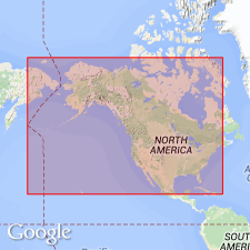
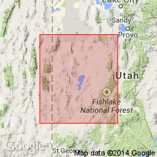
Type locality: southeast of Pioche, on road to Panaca, [Pioche quadrangle, Lincoln Co., western NV].
Source: US geologic names lexicon (USGS Bull. 896, p. 1668-1669).
- Usage in publication:
-
- Pioche Formation
- Modifications:
-
- Revised
- Redescribed
- Dominant lithology:
-
- Quartzite
- Siltstone
- Shale
- Limestone
- AAPG geologic province:
-
- Great Basin province
Summary:
At type in Pioche district, NV, unit has very similar lithology and paleontology to combined Pioche and Tatow Formations in House Range, west-central UT. Thus Tatow is reduced to member rank and assigned to Pioche in Fish Springs, House, Wah Wah and Cricket Ranges, Great Basin province. Revised Pioche consists of an unnamed lower member and Tatow in upper part. From chart, lower member correlates with Cabin Shale and Busby Quartzite in Deep Creek and Dugway Ranges and Drum Mountains and in part with Tintic Quartzite in East Tintic Mountains; Tatow correlates with lowermost part of Abercrombie Formation in Deep Creek Range, lower part of Shadscale Formation in Dugway Range and part of Tintic Quartzite in East Tintic Mountains; all in west-central UT. In House Range, lower part of revised Pioche is predominantly quartzite with interbedded siltstone and shale and contains late Early Cambrian BONNIA-OLENELLUS fauna; Tatow is predominantly quartzite with interbedded shale, siltstone and limestone and contains an early Middle Cambrian ALBERTELLA Zone fauna in its upper part. Lower-Middle Cambrian boundary in House Range probably is located near contact between two members. Because of heterogeneous lithology, name Pioche Formation is more appropriate than Pioche Shale at all localities in eastern NV and west-central UT. Overlies Prospect Mountain Quartzite; underlies Howell Limestone. Early and Middle Cambrian age.
Source: GNU records (USGS DDS-6; Denver GNULEX).
For more information, please contact Nancy Stamm, Geologic Names Committee Secretary.
Asterisk (*) indicates published by U.S. Geological Survey authors.
"No current usage" (†) implies that a name has been abandoned or has fallen into disuse. Former usage and, if known, replacement name given in parentheses ( ).
Slash (/) indicates name conflicts with nomenclatural guidelines (CSN, 1933; ACSN, 1961, 1970; NACSN, 1983, 2005, 2021). May be explained within brackets ([ ]).