

- Usage in publication:
-
- Pineville sandstone
- Modifications:
-
- Named
- Dominant lithology:
-
- Sandstone
- AAPG geologic province:
-
- Appalachian basin
Summary:
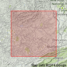
Named the Pineville sandstone of the Pottsville group for Pineville, Wyoming Co., southern WV. Consists of massive to current-bedded, medium-grained, buff to bluish gray sandstone. Thickness is 50 to nearly 100 feet. Unit overlies the Pocahontas No. 9 coal and underlies the Little Fire Creek coal. The Pineville is of Pennsylvanian age.
Source: GNU records (USGS DDS-6; Reston GNULEX).
- Usage in publication:
-
- Pineville sandstone
- Modifications:
-
- Revised
- AAPG geologic province:
-
- Appalachian basin
Summary:
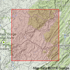
Revised the Pineville sandstone to be included in the New River group in WV. Consists of massive, grayish white, coarse-grained sandstone. Thickness is 30 to 50 feet. Locally its position in column is occupied by shale.
Source: GNU records (USGS DDS-6; Reston GNULEX).
- Usage in publication:
-
- Pineville Sandstone Member*
- Modifications:
-
- Revised
- Areal extent
- AAPG geologic province:
-
- Appalachian basin
Summary:
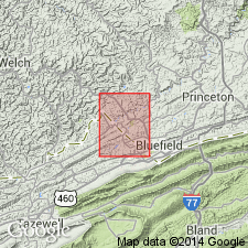
Revised the Pineville to the Pineville Sandstone Member of the New River Formation and geographically extended it to southwestern VA. Consists of light gray, medium- to coarse-grained, cross-bedded sandstone that contains 65 percent quartz with feldspar, mica, and dark minerals. Thickness is 12 to 16 feet. Overlies the Pocahontas No. 9 coal bed and underlies main part of New River Formation. The Pineville is of Early Pennsylvanian age.
Source: GNU records (USGS DDS-6; Reston GNULEX).
- Usage in publication:
-
- Pineville Sandstone Member*
- Modifications:
-
- Overview
- AAPG geologic province:
-
- Appalachian basin
Summary:
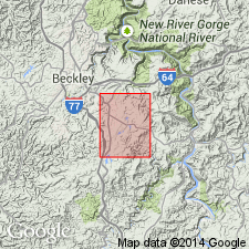
The Pineville Sandstone Member of the New River Formation in southern WV is 30 to 120 feet thick. Unit overlies the Pocahontas Formation and underlies the Little Fire Creek coal bed. The Pineville is of Early Pennsylvanian age.
Source: GNU records (USGS DDS-6; Reston GNULEX).

- Usage in publication:
-
- Pineville Sandstone Member*
- Modifications:
-
- Areal extent
- AAPG geologic province:
-
- Appalachian basin
Summary:
Pineville Sandstone Member of New River Formation is found only in WV.
Source: GNU records (USGS DDS-6; Reston GNULEX).
For more information, please contact Nancy Stamm, Geologic Names Committee Secretary.
Asterisk (*) indicates published by U.S. Geological Survey authors.
"No current usage" (†) implies that a name has been abandoned or has fallen into disuse. Former usage and, if known, replacement name given in parentheses ( ).
Slash (/) indicates name conflicts with nomenclatural guidelines (CSN, 1933; ACSN, 1961, 1970; NACSN, 1983, 2005, 2021). May be explained within brackets ([ ]).