The National Geologic Map Database is migrating to a new infrastructure. We apologize for any service disruptions during this process.
|
|---|


- Usage in publication:
-
- Pinedale stage*
- Pinedale drift*
- Modifications:
-
- Original reference
- Dominant lithology:
-
- Till
- AAPG geologic province:
-
- Green River basin
- Wind River basin
- Yellowstone province
Summary:
Pg. 310, 324-340. Pinedale stage. The youngest moraines, which for convenience may be called Pinedale drift, are conspicuous around each of the large lakes near Pinedale on southwest side of Wind River Range, [Sublette County], central western Wyoming. [Age is Pleistocene.]
Source: US geologic names lexicon (USGS Bull. 896, p. 1663).
- Usage in publication:
-
- Pinedale glacial stage*
- Modifications:
-
- Age modified
- Dominant lithology:
-
- Till
- AAPG geologic province:
-
- Great Basin province
Summary:
Pg. 865-922. Pinedale glacial stage. Correlated this drift with Wisconsin glacial stage. [Age is Pleistocene.]
Source: US geologic names lexicon (USGS Bull. 896, p. 1663).
- Usage in publication:
-
- Pinedale glaciation*
- Modifications:
-
- Areal extent
- AAPG geologic province:
-
- Estancia basin
- San Luis basin
Summary:
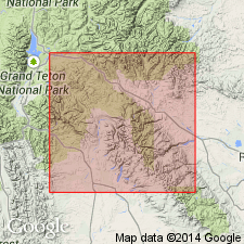
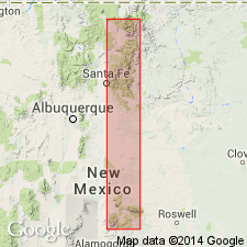
Divisible into three well-preserved rough bouldery moraines -early, middle, and late stades, in canyons upstream from the Bull Lake glaciation. Has immature soils 1-2 ft thick. Outwash gravels underlie separate terraces or form compound fills. Thin azonal soil or dark alluvial silty-clay separates early and middle stades. These characteristics of the glaciation in the Wind River Mountains of WY can be recognized at 3 localities in central NM. Moraines of the 3 stades are recognized at 1) Wheeler Peak to Rio Hondo area west side of Sangre de Cristo Mountains, NM in the San Luis basin, 2) Lake Peak, Rio Nambe, Santa Fe Co, NM in the Estancia basin, and 3) Sierra Blanca Peak, Santa Fe Co, NM in the Estancia basin. Small maps delineate occurrence in each area. Correlation chart. The early stade occurs at 10,200 ft at Wheeler Peak, at 10,750 ft at Lake Peak, Rio Nambe, and at 10,500 ft at Sierra Blanca Peak. The middle stade occurs at 10,850 ft at Wheeler Peak, at 11,100 ft at Lake Peak, and at 10,900 ft at Sierra Blanca Peak. The late stade occurs at 11,000 ft at Wheeler Peak, at 11,400 ft at Lake Peak, and 11,300 ft at Sierra Blanca Peak. Of late late Pleistocene age.
Source: GNU records (USGS DDS-6; Denver GNULEX).
- Usage in publication:
-
- Pinedale glaciation*
- Modifications:
-
- Areal extent
- AAPG geologic province:
-
- Wasatch uplift
Summary:
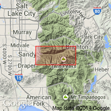
Deposits formed during Pinedale include till, rock glaciers, outwash gravel, alluvial-fan gravel, talus, protalus, and landslides; they are upstream or upslope from, locally overlap, or are entrenched within those formed during the Bull Lake glaciation. They bear an immature Brown Podzolic soil. They are overlapped by younger deposits of the Neoglaciation, or are cut by channels containing such deposits. Divisible into lower, middle, and upper tills that are assignable to the early, middle, and late stades of the glaciation representing a maximum advance of ice followed by two recessional stands or minor advances. Mapped (geologic map) in Little Cottonwood and Bells Canyons in the Wasatch Mountains, Salt Lake Co., UT on the Wasatch uplift. Detailed description of deposits at many localities in the Wasatch Mountains. Of Pleistocene age.
Source: GNU records (USGS DDS-6; Denver GNULEX).
- Usage in publication:
-
- Pinedale glaciation*
- Modifications:
-
- Age modified
- AAPG geologic province:
-
- Montana folded belt
Summary:
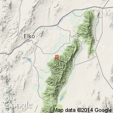
Moraines of West Yellowstone are correlated with type Pinedale and Bull Lake (200 km southeast of West Yellowstone) on basis of relative morphologic expression, soil development, basalt weathering rinds, loess mantle, degree of breaching by streams, and geologic sequence. Obsidian hydration rinds on glacially abraded obsidian from Pinedale and Bull Lake moraines indicate an age of about 30,000 and 140,000 yr, respectively. Previous age estimates of Pinedale and Bull Lake glaciations are significantly younger than the ages determined in this study. Pinedale glaciation correlates with much or all of Wisconsin glaciation rather than with late Wisconsin and Bull Lake moraines correlate with younger part of Illinoian glaciation rather than with early Wisconsin glaciation as commonly believed.
Source: GNU records (USGS DDS-6; Denver GNULEX).
- Usage in publication:
-
- Pinedale Till*
- Modifications:
-
- Overview
- Dominant lithology:
-
- Till
- AAPG geologic province:
-
- Green River basin
Summary:
Though no stratotype ever designated, holostratotype area [type area] designated where Blackwelder (1915) described moraines around large lakes near Pinedale and where sequence of typical Pinedale moraines are mapped by Richmond (1973, USGS GQ-1138) around and along Fremont Lake, within Sublette Co, WY, Greater Green River basin. Unit described as a sequence of up to seven rough, very bouldery, hummocky end moraines composed almost wholly of clasts of Precambrian crystalline rocks in a sandy matrix. Pinedale recognized as a deposit of valley glaciers and local upland icecaps throughout the Rocky Mountains. Assigned late Wisconsinan age.
Source: GNU records (USGS DDS-6; Denver GNULEX).
For more information, please contact Nancy Stamm, Geologic Names Committee Secretary.
Asterisk (*) indicates published by U.S. Geological Survey authors.
"No current usage" (†) implies that a name has been abandoned or has fallen into disuse. Former usage and, if known, replacement name given in parentheses ( ).
Slash (/) indicates name conflicts with nomenclatural guidelines (CSN, 1933; ACSN, 1961, 1970; NACSN, 1983, 2005, 2021). May be explained within brackets ([ ]).