

- Usage in publication:
-
- Pigeon Creek Formation
- Modifications:
-
- Named
- Dominant lithology:
-
- Mudstone
- Sandstone
- Conglomerate
- Limestone
- AAPG geologic province:
-
- Great Basin province
- Wasatch uplift
Summary:
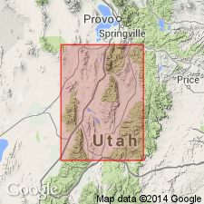
Named as a term to be applied to rocks in central UT formerly assigned to Morrison? Formation by some, to Morrison? and Indianola Group by some, or to Cedar Mountain Formation and Indianola Group by others. Stratigraphic charts. Measured section of stratotype in sec 25, T14S, R1E, Juab Co, where it unconformably overlies Twist Gulch Formation and unconformably underlies Indianola Group. Named for Pigeon Creek Canyon in the Levan quad. Divided into lower member 185 m thick of red mudstone intercalated with channel-form and sheet sandstone, sheet conglomerate, and minor freshwater limestone, and an upper member 790 m thick of sheet conglomerate interbedded with thin red mudstone beds. Lower member ranges between 100 and 200 m thick, and upper member ranges between 150 and 250 m thick. Several measured sections. Conglomerate dominated by carbonate clasts from Devonian and Mississippian rocks and by quartzite clasts from Precambrian and Cambrian quartzites derived probably from a tectonically controlled western source. Crops out as far north as Thistle, Utah Co, south to Salina, Sevier Co, Wasatch uplift. Crops out continuously on Gunnison Plateau, Great Basin province. Ranges in age from late Neocomian to late Albian. Palynomorphs, leaf impressions. Is an alluvial foreland basin-fill sequence part of an ephemeral braided stream system with a muddy basin interspersed with lacustrine depressions.
Source: GNU records (USGS DDS-6; Denver GNULEX).
- Usage in publication:
-
- Pigeon Creek Formation
- Modifications:
-
- Not used
Summary:
Not used. Conglomerate beds underlying Sanpete Formation of Indianola Group and overlying Cedar Mountain Formation in area of Pavant Range-Canyon Range and Gunnison Plateau-Valley Mountain of Juab Co, UT, Great Basin province, are referred to as "unnamed conglomerate" of Albian age.
Source: GNU records (USGS DDS-6; Denver GNULEX).
For more information, please contact Nancy Stamm, Geologic Names Committee Secretary.
Asterisk (*) indicates published by U.S. Geological Survey authors.
"No current usage" (†) implies that a name has been abandoned or has fallen into disuse. Former usage and, if known, replacement name given in parentheses ( ).
Slash (/) indicates name conflicts with nomenclatural guidelines (CSN, 1933; ACSN, 1961, 1970; NACSN, 1983, 2005, 2021). May be explained within brackets ([ ]).