The National Geologic Map Database is migrating to a new infrastructure. We apologize for any service disruptions during this process.
|
|---|


- Usage in publication:
-
- Piegan group
- Modifications:
-
- Original reference
- Dominant lithology:
-
- Limestone
- Dolomite
- Quartzite
- Argillite
- Shale
- AAPG geologic province:
-
- Northern Rocky Mountain region
Summary:
Pg. 1890-1892. Piegan group. Limestones, dolomites, and dominantly argillaceous clastics which lie between Missoula and Ravalli groups. Despite variations, they form the sole dominantly calcareo-magnesian group in the Meagher facies and the second in the Glacier Park. Characterized by great development of calcareous algae. Contains Siyeh, Spokane, and Sheppard formations in ascending order at type locality. Age is Precambrian (Belt).
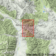
Type locality: Piegan Mountain, Glacier National Park, [Glacier Co.], western MT. Well exposed on Mounts Gould, Wilbur, Cleveland, Lineham, and other high peaks of Glacier-Waterton region [Montana, and British Columbia and Alberta, Canada].
Source: US geologic names lexicon (USGS Bull. 1200, p. 3010-3011).
- Usage in publication:
-
- Piegan group*
- Modifications:
-
- Areal extent
- AAPG geologic province:
-
- Northern Rocky Mountain region
Summary:
Oldest unit in Bonner quad, Missoula Co, MT in the Northern Rocky Mountain region, is Newland limestone of Piegan group of Belt series. Newland is approximately equivalent to Siyeh and Wallace limestones of Piegan and is used in preference to Wallace even though Clapp and Deiss (1931) used Wallace within report area. Of Precambrian age. Geologic map; stratigraphic chart.
Source: GNU records (USGS DDS-6; Denver GNULEX).

- Usage in publication:
-
- Piegan group*†
- Modifications:
-
- Abandoned
Summary:
Mapping in northwestern MT, Lewis and Clark Co, Northern Rocky Mountain region, supports the correlation of Helena dolomite, Cayuse limestone, Wallace formation, and Siyeh limestone as stratigraphic equivalents; therefore, term Piegan group abandoned. Cayuse also abandoned.
Source: GNU records (USGS DDS-6; Denver GNULEX).
For more information, please contact Nancy Stamm, Geologic Names Committee Secretary.
Asterisk (*) indicates published by U.S. Geological Survey authors.
"No current usage" (†) implies that a name has been abandoned or has fallen into disuse. Former usage and, if known, replacement name given in parentheses ( ).
Slash (/) indicates name conflicts with nomenclatural guidelines (CSN, 1933; ACSN, 1961, 1970; NACSN, 1983, 2005, 2021). May be explained within brackets ([ ]).