The National Geologic Map Database is migrating to a new infrastructure. We apologize for any service disruptions during this process.
|
|---|


- Usage in publication:
-
- Pen Formation
- Modifications:
-
- First used
- Dominant lithology:
-
- Marl
- Clay
- Limestone
- Sandstone
- AAPG geologic province:
-
- Permian basin
Summary:
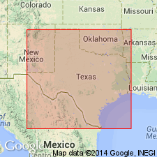
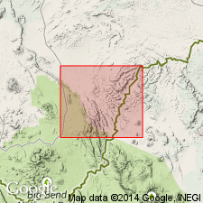
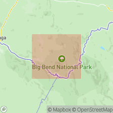
First used as top formation of Terlingua Group (revised) of Gulfian Series in Big Bend National Park area, Brewster Co, TX in the Permian basin. Type not designated; derivation of name not stated. Overlies San Vicente Member (new) of Boquillas Formation (revised); underlies Aguja Formation at base of Tornillo Group (revised). Includes middle and upper members of Udden's (1907) Terlingua Beds. Is dark grayish-blue gypsiferous marl and clay that weathers yellow, with concretionary limestone and layers of calcareous sandstone. Ranges from 200 to 600 ft thick; 400 ft thick in most places. Is soft and occurs as belt of low topography between more resistant Boquillas below and Aguja above; is mostly covered. Concretions are the most conspicuous lithographic feature; most are disk-shaped, are as much as 4 ft in diameter, and may be fossiliferous. Common fossils listed. Is of Austin age and considered correlative with Dessau and Burditt [Formations] in central TX. Age is Coniacian and Santonian (Late Cretaceous).
Source: GNU records (USGS DDS-6; Denver GNULEX).
- Usage in publication:
-
- Pen Clay
- Modifications:
-
- Overview
- AAPG geologic province:
-
- Permian basin
Summary:
Is upper formation of two in Terlingua Group. Is youngest Cretaceous strata mapped in Black Gap area, Brewster Co, TX in southern part of Permian basin. Crops out only in the basalt-capped center part of map area, where resistant basalt cover has protected the easily eroded clay. Overlies Boquillas Formation. Is unconformably overlain by Tertiary basalt. Calculated thickness is 500 ft in map area. INOCERAMUS GRANDIS reported to occur near Bee Cave Tank 3 mi northwest of Black Gap headquarters. Clay itself suggests sediments laid down by a regressing sea; gypsum in the clay suggests shallow-water evaporitic conditions. Included in Gulf Series. Age is Cretaceous.
Source: GNU records (USGS DDS-6; Denver GNULEX).
- Usage in publication:
-
- Pen Formation
- Modifications:
-
- Named
- Dominant lithology:
-
- Clay
- Sandstone
- AAPG geologic province:
-
- Permian basin
Summary:
Named as upper formation of two in Terlingua Group (revised) in Gulfian Series. Named from Chisos Pen north of the Chisos Mountains, Brewster Co, TX (southern part of Permian basin). Type section (measured by planetable) about 2 mi north of Hot Springs (see pl. VIII, no. 21) is 457 ft thick; both base and top exposed, but most beds are covered. Base is gray calcareous clay, mostly covered, lying 18 ft above INOCERAMUS UNDULATOPLICATUS beds in the San Vicente Member (new) of Boquillas Formation. Top is gray clay with EXOGYRA PONDEROSA that terminates at base of 20-ft-thick, yellowish-gray sandstone ledge of the basal Aguja Formation. Base of 40-ft-thick concretion-bearing interval with abundant ammonites, pelecypods, and gastropods is 310 ft above formation base. Molluscan fossils listed. Faunal assemblage suggests an upper Austin age. Correlates with the lower Anacacho and Upon in the Anacacho Mountains, the Dessau Chalk in the Austin area, some part of the Austin section above the hiatus described by McNulty (1955) in northeast TX, and with some part of the Brownstown Marl in northeast TX, LA, and AR. Is shown as Santonian and Campanian on Table 2. Age is Late Cretaceous.
Source: GNU records (USGS DDS-6; Denver GNULEX).
- Usage in publication:
-
- Pen Formation
- Modifications:
-
- Mapped 1:250k
- AAPG geologic province:
-
- Permian basin
Summary:
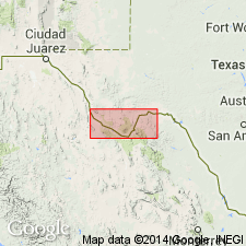
Is Upper Cretaceous formation mapped in Brewster and Presidio Cos, TX in southern part of Permian basin. Overlies San Vicente Member of Boquillas Formation. Overlain by Aguja Formation. Equivalent to upper part of Austin Chalk. Is mostly clay; upper part sandy with some sandstone beds as thick as 5 ft; middle part, yellow, scattered sandy beds; lower 50 ft, calcareous clay with inch-thick chalk beds, light bluish gray; concretions common throughout, mostly calcareous, some clay-ironstone; weathers yellow to yellowish gray, topographically low. Marine fossils throughout, EXOGYRA PONDEROSA common. Thickness: 219 to 700 ft in Big Bend National Park, 1,000 ft in Terlingua area, 200 ft in Bofecillos area, also crops out in Black Gap area.
Source: GNU records (USGS DDS-6; Denver GNULEX).
For more information, please contact Nancy Stamm, Geologic Names Committee Secretary.
Asterisk (*) indicates published by U.S. Geological Survey authors.
"No current usage" (†) implies that a name has been abandoned or has fallen into disuse. Former usage and, if known, replacement name given in parentheses ( ).
Slash (/) indicates name conflicts with nomenclatural guidelines (CSN, 1933; ACSN, 1961, 1970; NACSN, 1983, 2005, 2021). May be explained within brackets ([ ]).